|
||

|

|
|

|
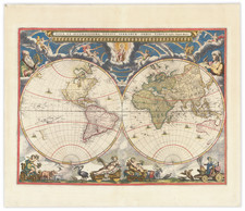
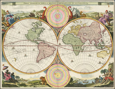
Rare, Spectacularly Illustrated Carte-à-Figures World Map
Rare, richly embellished carte-à-figures world map by prominent Dutch cartographer Jan Jansson.
The present map’s most striking features are its vibrantly illustrated borders, cartouches, and inset panels, which, according to Shirley, “exemplify Dutch engraving and decorative skills of the early seventeenth century.”
Along the upper border, eight European rulers are depicted on horseback, while along the lower border are ten scenes of paired male and female costume figures from around the world. Some of these figures are taken from Claes Janszoon Visscher’s world map of 1614.
Nine vignettes along each side border depict major cities across the globe. Insets in the lower left and right corners illustrate Biblical scenes: the left inset depicts Adam and Eve in the Garden of Eden, with Adam, rather than Eve, reaching for the forbidden fruit; the right inset depicts the apocalyptic aftermath of Adam and Eve’s original sin, with the pair being driven out of Eden by the devil.
A large cartouche extending into North America in the upper left corner of the map lists the major explorers of the Americas, including Christopher Columbus, Amerigo Vespucci, Francis Drake, and Ferdinand Magellan, with the dates of their expeditions; this text is bordered with oval portraits of the explorers. A smaller ornate cartouche in the upper right corner of the map gives the place and year of the map’s publication and credits Jansson.
Additional illustrative content on the map itself includes large sailing ships, smaller boats, and whales in the Atlantic, Pacific, and Indian Oceans. There is also a sea battle off the coast of what is today Chile.
The geography of the present map also contains many noteworthy features, especially polar exploration, Terra Australis, the Strait of Anian, and legendary cities of gold.
Geographic content: exploration north and south
North America, whose northern coastline is incomplete, is greatly exaggerated along its west coast. The northern interior of the continent also lacks the numerous place names and topographic information that is otherwise present, reflecting the state of geographic knowledge about the continent in the seventeenth century. In present-day northeastern Canada, to the right of the large cartouche, a note references British explorer John Davis’ 1585–1587 quest to locate a Northwest Passage, during which he explored the Davis Strait (depicted on the present map) and Cumberland Gulf (now Sound) and located the entrance to Hudson Strait. To the right of this note, two figures are depicted, one holding a bow and kayak.
The present map also depicts several other voyages of discovery. A dotted line leading westward from the Netherlands traces the 1615–1617 voyage of navigators Jacob Le Maire and Willem Corneliszoon Schouten to discover a new route to the Moluccas, an important center of the spice trade. Le Maire and Schouten discovered a strait between Tierra del Fuego, the island at the southern tip of South America, and present-day Isla de los Estados, Argentina. Here, the island is shown as a peninsula, Staten Land, connected to the vast southern continent of Terra Australis. This newly discovered Strait of Le Maire provided an alternative route to the Pacific than the Straits of Magellan, which were technically under the purview of the Dutch East India Company.
Another set of expeditions noted are the three voyages of Dutch navigator William Barents in 1594–1596, in search of a Northeast Passage from Europe to Asia. Barents rounded the north of the Arctic archipelago Novaya Zemlya (Nova Zemla), but died after his expedition became trapped in ice and was forced to winter in place. Novaya Zemlya is depicted here as an extended peninsula, whose coastline runs due north-south for almost 1,000 miles.
Geographic content: Terra Australis
It is hard to miss the massive continent Magallanica, or Terra Australis, extending across the southern border of the map. The idea of this mythical southern continent originated in Ancient Greece, where Aristotle theorized that a large antipodean continent must exist as a counterweight to the known Northern Hemisphere. Terra Australis can be seen on some medieval mappaemundi.
Portuguese explorers in the early sixteenth century likely thought they had come across Terra Australis when they reached the mouth of the Rio de la Plata, separating present-day Uruguay and Argentina, as the river’s southern banks were so distant, they appeared to form a separate landmass. It was also thought that the land forming the southern shores of the Strait of Magellan—Tierra del Fuego—could be Terra Australis—a theory depicted in Oronce Fine’s world map of 1531. Some took Marco Polo and other medieval travelers’ descriptions of Southeast Asian lands to be proof of Terra Australis. After an eastern route across the Pacific from the Philippines was discovered in the 1560s, additional discoveries were attributed to the mythical continent.
New Australasian encounters were first thought to be part of this southern continent, including Abel Tasman’s voyage to New Zealand in 1642. As Australia and New Zealand continued to be explored throughout the next century, it became increasingly clear that Terra Australis could not exist, but it was not until the nineteenth century that its existence was conclusively ruled out.
Strait of Anian
The Strait of Anian can be seen both at the northeastern and northwestern borders of the present map. This strait, believed to separate northwestern America from northeastern Asia, was related to the centuries-long quest to find a Northwest Passage connecting the Atlantic Ocean to the Pacific. Appearing on maps beginning in the mid- to late-fourteenth century, the rumor of this strait and a Northwest Passage in general inspired many voyages of discovery, including those of John Cabot, Sir Francis Drake, Gaspar Corte-Real, Jacques Cartier, and Sir Humphrey Gilbert.
The term Anian itself comes from Marco Polo’s thirteenth-century accounts of his travels. Polo used the term to refer to the Gulf of Tonkin, but cartographers at the time of Jansson thought it could refer to this supposed strait between Asia and North America. The Strait of Anian, so named, first appeared in a 1562 map by Giacomo Gastaldi, and was later adopted by Bolognini Zaltieri and Gerardus Mercator.
A few decades later, English financier Michael Lok advanced the story of Juan de Fuca (the Castilianized name of Greek navigator Ioánnis Fokás), who supposedly sailed the Strait of Anian. Little archival evidence survives of Fuca’s career, but according to Lok, Fuca reported that he had been sent north from New Spain twice in 1592 in search of the Strait of Anian.
Fuca supposedly traveled up a vast straight at the northernmost point of the west coast of America, around which he sailed for more than twenty days. The Spanish Crown failed to reward Fuca’s discovery of an opening in the coast at roughly 47° N latitude and Fuca left the Spanish service embittered. His story lived on in Lok’s letters and eventually was published in Samuel Purchas’ travel collection of 1625. Fuca’s account helped to keep this chimerical strait on many maps of the time. It was not until 1772 that Samuel Hearne conclusively disproved the strait’s existence.
Legends of Gold
The present map references the persistent European belief that the Americas were a land of gold. In South America are two lakes, Parima and Eupana, which are traditionally fictional locations of El Dorado. In the sixteenth and seventeenth centuries, Europeans believed El Dorado to be a place of immense riches somewhere in the New World. Spanish explorers of South America in the sixteenth century heard legends of a ruler of a tribe in the Andes Mountains in present-day Colombia who was covered in gold dust; they referred to him as “the gilded one.” Although this legendary tribe was never located, this did not end the belief in El Dorado. In the seventeenth century, Sir Walter Raleigh traveled twice to Guiana to search for El Dorado. This expedition was not fruitful and led to the death of both Raleigh and his son.
In North America, the map depicts the legend of the Seven Cities of Gold with the place names Ceptem Citta and Cevola (Cibola). Spanish explorers heard many rumors of the Seven Cities of Cibola, a supposed land of gold and riches. In 1539 Franciscan priest Friar Marcos de Niza reported to Spanish colonial officials in Mexico City that he’d seen the legendary city of Cibola in present-day New Mexico. In response to this report, a large, expensive Spanish expedition took place in 1541, but no riches were found, and the expedition caused massive debt.
These entertaining mythical and conjectural geographic elements, combined with richly illustrated borders, cartouches, and panels, make the present map a striking example of the Dutch Golden Age of cartography.
States and rarity
The present map was originally published by Dirck Lons in 1622 and is based on Pieter van den Keere’s Mercator projection world map of 1608. Lons’ map added new cartouches and decorative borders, which can be seen in the versions published under Jansson’s imprint in 1626 and 1632, thus making the present map the third state of the world map.
The present map is present in the collections of fewer than five institutions. It is very rare on the market.
https://www.wdl.org/en/item/3970/; Rodney Shirley, The Mapping of the World: Early Printed World Maps, 1472–1700 (London: Holland Press, 1983), XXXII–XXXIII, 329–330 (No. 309); Thomas Suarez, Early Mapping of Southeast Asia (Singapore: Periplus Editions, 1999); “William Barents,” Encyclopaedia Britannica, accessed May 31, 2020, https://www.britannica.com/biography/Willem-Barents. AH
Jan Janssonius (also known as Johann or Jan Jansson or Janszoon) (1588-1664) was a renowned geographer and publisher of the seventeenth century, when the Dutch dominated map publishing in Europe. Born in Arnhem, Jan was first exposed to the trade via his father, who was also a bookseller and publisher. In 1612, Jan married the daughter of Jodocus Hondius, who was also a prominent mapmaker and seller. Jonssonius’ first maps date from 1616.
In the 1630s, Janssonius worked with his brother-in-law, Henricus Hondius. Their most successful venture was to reissue the Mercator-Hondius atlas. Jodocus Hondius had acquired the plates to the Mercator atlas, first published in 1595, and added 36 additional maps. After Hondius died in 1612, Henricus took over publication; Janssonius joined the venture in 1633. Eventually, the atlas was renamed the Atlas Novus and then the Atlas Major, by which time it had expanded to eleven volumes. Janssonius is also well known for his volume of English county maps, published in 1646.
Janssonius died in Amsterdam in 1664. His son-in-law, Johannes van Waesbergen, took over his business. Eventually, many of Janssonius’ plates were sold to Gerard Valck and Pieter Schenk, who added their names and continued to reissue the maps.
![(Second World War) Der Grossasiatisch-Amerikanische Raum [The Great Asiatic-American Space]](https://storage.googleapis.com/raremaps/img/small/88834.jpg)