


|
||

|

|
|

|
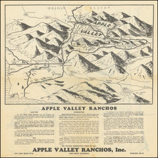
Rare separately published map of Pasadena, printed by Kitts & Jeffries in Los Angeles.
The map is centered on the Santa Fe Train Depot, with the Green Hotel and Carleton Hotel across the street. The Fire Department, Los Angeles T. Depot and Grand Opera House appear in the center circle, along with several other hotels, with the Raymond Hotel and Southern Pacific Stations at the far left.
Pasadena
Pasadena is a part of the original Mexican land grant named Rancho del Rincon de San Pascual. The Rancho comprised the lands of today's communities of Pasadena, Altadena and South Pasadena. The last of the Mexican grant owners was Manuel Garfias, who retained title to the property after statehood in 1850. Garfias sold sections of the property to the first Anglo settlers to come into the area: Benjamin Eaton, the father of Fred Eaton, and Dr. S. Griffin. Much of the property was purchased by Benjamin Wilson who established his Lake Vineyard property in the vicinity. Wilson, was also owner of the Rancho Jurupa (Riverside, California) and mayor of Los Angeles.
In 1873, Wilson was visited by one Dr. Daniel M. Berry of Indiana who was looking for a place in the country that could offer better climate to his patients, most of whom suffered from tuberculosis. Berry formed the Southern California Orange and Citrus Growers Association and purchased a large portion of the property along the Arroyo Seco, creating the Indiana Colony. As a gesture of good will, Wilson added 2,000 acres of then useless highland property, part of which would become Altadena. the Indiana Colony was a narrow strip of land between the Arroyo Seco and Fair Oaks Avenue. On the other side of the street was Wilson's Lake Vineyard development. After more than a decade of parallel development on both sides, the two settlements merged into the City of Pasadena.
In March 1886, Pasadena became the second incorporated municipality, after the city of Los Angeles, in Los Angeles County. From the real estate boom of the 1880s until the Great Depression, as great tourist hotels were developed in the city, Pasadena became a winter resort for wealthy Easterners. Pasadena was served by the Atchison, Topeka and Santa Fe Railway at the Santa Fe Depot in downtown when the Second District was opened in 1887.
Rarity
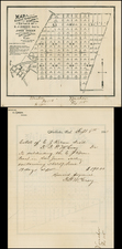
This is the earliest printed map of Pasadena we have ever offered for sale.
No copies are listed in OCLC, but there is a similar map in same size and formant, "B.O. Kendall's map of Pasadena, Cal. Corrected to Aug. 1st, 1895," of which one copy is listed, at The Claremont Colleges (just east of Pasadena).
![[Corona Del Mar]](https://storage.googleapis.com/raremaps/img/small/66927.jpg)
![(California Lithography) N.S.G.W. Certificate of Membership. This is to Certify that [blank] is a member of Native Sons of the Golden West](https://storage.googleapis.com/raremaps/img/small/93308.jpg)