|
||

|

|
|

|
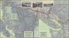
With Annotations By An Early Logging Concern?
Important early Map of Southwestern British Columbia, published by the Department of Lands and Works.
The map which depicts the relative locations of various Land Districts and Divisions in south-west British Columbia. The map also shows physical features (though not topography) and transportation routes.
The map shows the progress of the government surveys on either side of the Strait of Georgia, along with early railroad lines, roads, canals, etc. The details in the back country include early post offices and Hudson Bay Company Trading Houses,
The map was issued periodically between 1892 and 1911, under the auspices of different Chief Commissioners, who are often named on the map.
The map includes annotations in red, yellow and blue, primary around Flores Island and Herbert Arm, in Clayoquot Sound. This almost certainly related to land speculation claims relating to Crown Timber Lands. In the first decade of the 20th Century, changing policy allowed for speculators to claim up to a square mile of crown timber lands.
Rarity
We note a single example offered for sale in a dealer Catalog (Francis Edwards 1967).
![[Collection of 10 manuscript charts and maps depicting the west coast of North America from Monterey, California, to just north of Salisbury Sound, Alaska.]](https://storage.googleapis.com/raremaps/img/small/98898.jpg)