|
||

|

|
|

|
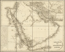
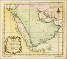
An Important Map of the Arabian Peninsula
Rare geological map, showing oil fields, pipelines and terminals.
Detailed map of the complete Arabian Peninsula, based on the groundbreaking series prepared by the U.S. Geological Survey and the Arabian American Oil Company under the joint sponsorship of the Kingdom of Saudi Arabia and the U.S. Department of State.
The map also includes the territories of today's Kuwait, Qatar, Bahrain, United Arab Emirates, Oman, and Yemen.
Although the search for oil, gas and minerals was ultimately to drive geological survey work across the region—and still does today—in its early years it was the need for water that was the catalyst for Saudi Arabia 's resource exploration. In 1944 King ‘Abd al-‘Aziz approached the United States for a technical expert who could assist with the identification and plotting of the kingdom's natural resources, particularly its groundwater reserves. The individual who arrived, Glen F. Brown, was one of the pioneers of a partnership between the United States Geological Survey (USGS) and the government of Saudi Arabia that was to span the next five decades and play an important role in the development of the kingdom. Brown was initially charged with carrying out surveys of much of western and central Arabia, and he gathered his information in much the same way as earlier travelers. Using modern equipment, but still traveling part of the time on foot or by donkey, Brown and his companion, Richard Bramkamp of Aramco, measured temperature and humidity, identified and estimated the extent and quality of water and mineral resources and calculated topographical data. It is estimated that the two covered more than 38,000 square kilometers (15,000 sq mi) in little more than 18 months—an extraordinary achievement.
Soon afterward, such work was dramatically supplemented by aerial photography, and by 1954 the Saudi Ministry of Finance, USGS and Aramco were working together to produce the first full series of geographic and geologic maps of the country. The first of their type in the Peninsula, these were published between 1960 and 1963 in both Arabic and English versions, and the information they contained formed the basis of subsequent Saudi national development plans. To this day, all modern maps of the kingdom trace their roots back to these first publications.
The map includes an Arabic-English Glossary and notes a number of important features, including:
- Oil Pipe Lines and Terminals
- Oil Refineries
- Pumping Stations and gas and oil separation plants
- Important Desert Watering Points
- Water pipelines
- Airports and Landing Fields
- Railroads and Abandoned Railroads
- Various Roads and Trails