


|
||

|

|
|

|
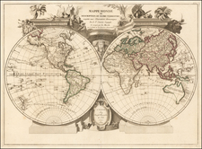
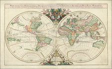
Striking large format decorative double hemisphere map of the World by Santini.
The map shows the Sea of the West, an interesting conjectural projection of the NW Coast of America based upon the Russian Voyages in the mid-18th Century, but retaining a direct NW passage via Hudson' Bay. The tracks of many of the 17th and early 18th Century explorations in the Pacific are shown, including Tasman's route in 1642, Quiros in 1605, Davis in 1686, Mendana in 1568, Anson's route in 1743, Magellan's route, and others. The projection of Australia is notable for its lack of a southern coastline and attachment to New Guinea. Only a small portion of the New Zealand coast has been discovered. A report of the discovery of Cape Circoncision in January 1739 is shown, representing the most southerly land point discovered to date. No sign of the Antarctic Continent.
Striking embellishments and rich hand coloring.
Paolo Santini (1729-1793) was an Venetian engraver known especially for his religious prints and fine cartographic engravings. He published in Venice and may have a been a member of the clergy. In his maps, he largely adopted and adapted the work of his French counterparts, especially the brothers de Vaugondy.
![(Second World War - Anti-British Propaganda) Français regardez cette carte [French, look at this map!]](https://storage.googleapis.com/raremaps/img/small/88492.jpg)