|
||

|

|
|

|
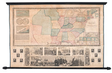
Striking example of this scarce large coast to coast map of the United States, issued in Weiland's Algemeiner Hand-Atlas. This is one of the best German atlas maps of the United States of the period. The detail in the Northwest is especially remarkable. Excellent detail in the Mississippi Valley and Missouri Valley. The discoveries of Lewis & Clark, Pike, Humboldt and Long are in evidence. While the cartographer apparently was updated on the recent information on California, the River from SF Bay to Salt Lake persists, although forced to run a course between two parrallel mountain ranges. Nice detail in Texas. Double wide Arkansas. Remarkable detail on the upper Colorado River and Rio Grande regions. Wisconsin and Minnesota are part of the NW T Territory and Michigan is a Territory. Nice detail in Texas, including a road from Ft. Miro to Cohuilla. A second river south of Monterrey connects the Pacific to the mythical Salt Lake below Timanagos. The River System in the Northwest and placenames and topography are unusually detailed. An nice example of this scarce and interesting map. Wheat 391. Inset of Washington DC.

![United States Atlas [rolled]](https://storage.googleapis.com/raremaps/img/small/91367.jpg)