|
||

|

|
|

|
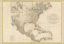
Rare first state of Gussefeld's map of the United States, published in the same year as the Louisiana Purchase and highlighting Jefferson's United States on the eve of the expedtitions of Lewis & Clark, Zebulon Pike, etc.
Following the Louisiana Purchase in 1805, there was a tremendous push to chart and explore the new American West. Gussefeld's map is illustrative of the extent of contemporary knowledge of the area purchased by Jefferson in 1803, including conjectural mountain ranges in the regions north and south of the Missouri River, scattered Indian Tribes and lots of conjecture.
There are two sepearate editions of this 1805 map. In this early edition, the following are the distinguishing features:
- Ohio is demarcated at an area above Kentucky, but below the eastern part of Indiana Territory, which extends from Pennsylvania to the Mississippi River.
- The northern boundary of Louisiana Territory is a serpentine line above Weisse Bar See.
- The Tennessee-North Carolina border runs due more or less due north and south.
- Georgia is separated from the future Mississippi Territory by a dotted line.
In the second state of the map, also dated 1805, there are some noteworthy changes: /gallery/detail/27579
- Ohio is now correctly placed, with an engraved Western Border.
- Louisiana Territory is now divided into Orleans, Mississippi and Louisiana.
- The Tennessee-North Carolina border is at a correct diagonal, following the Appalachians.
- Georgia extends to the Mississippi River.
The map is highly detailed, locating many early Indian Tribes, forts and important historical deails.
One of the best early depictions of the newly created Louisiana Territory.

![[ Slave and Free States -- Unusual Arizona / New Mexico Configuration ] Etats-Unis](https://storage.googleapis.com/raremaps/img/small/104270.jpg)

![The United States of America Confirmed By Treaty 1783 [shows Franklinia]](https://storage.googleapis.com/raremaps/img/small/84491.jpg)