|
||

|

|
|

|
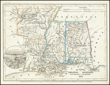
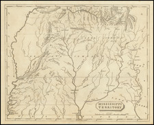
Rare engraved town plan of the site that would become Vicksburg, Mississippi, by famed French cartographer and spy Victor George Henri Collot.
In 1790, the Spanish founded a military outpost on the site of present-day Vicksburg, which they called Fort Nogales (nogales meaning "walnut trees"). When the Americans took possession in 1798 following the American Revolutionary War and a treaty with Spain, they changed the name to Walnut Hills. The small village was incorporated in 1825 as Vicksburg, named after Newitt Vick, a Methodist minister who had established a Protestant mission on the site.
In 1796, when Collot visited the fort, it was a place of great strategic importance. While at Nogales, Collot told Commandant Elias Beauregard that France was prepared to send 12,000 troops to reinforce the Spanish positions on the Mississippi River to defend against an American invasion.
This is the earliest map of the area of Vicksburg, Mississippi, listed in Phillips Maps.
The map includes a key listing the following places of interest:
A. Fort of the great Battery
B. Block-House
C. Fort Sugar-loaf
D. Ravin 12 feet deep
E. Elevated Plain
F. Fort Mount Vigie
G. Gor Gayoso
H. Fort St. Ignace
Fort Nogales History
The following is excepted from In and about Vicksburg: An Illustrated Guide Book to the City of Vicksburg:
The exact date of the building of the fort at Nogales is in doubt. . . . the best evidence [is] hat it was erected subsequent to the treaty of 1783. To Victor Collot . . . we indebted for a trustworthy account of the Spanish works at Nogales. During the year I796, M. Collot . . . journeyed down the Ohio to the Mississippi and along the latter to its mouth, making careful notes of his observations, which were published at Paris, in I826 . . . From this work we extract the following . . . . It may interest our antiquarians, who have differed for so many years as to the origin of the term which attaches to Vicksburg as the “Gibraltar of the South,” to know that the use of the appellation is older than the century, and that its origin, according to M. Collot, is founded in irony.
“The post of Nogales,” writes M. Collot, “called by way of irony the Gibraltar of Louisiana, is situated on the left of the river, near a deep creek, and on the summit of different eminences connected with each other and running northeast. These heights form a kind of spur, branching from the chain of hills, which is no longer visible, at the cliffs of Margot, and which falls away on the side of the Floridas. These eminences rise gradually toward the country-, dividing the space of forty miles from the banks of the river to the peak of this small chain. The first of these eminences—that is of those, that touch the banks of the river—do not form cliffs like those of the Iron Mine and at Margot; they slope away, on the contrary, very gradually, and it is at the extremity of one of their glacis that the first work, A, called fort of the Great Battery, is placed. But as after building this first fort it was perceived, in clearing, that at about two hundred yards behind, a small elevation commanded the battery, a block-house, B, was erected, on which were placed four howitzers pointed at the battery. On the side of the river this battery is closed by a wall of masonry, twelve feet high and four thick, in which are crannies and embrasures; on the land side, a ditch four feet in breadth and three deep, and a palisado twelve feet high, surround the battery and the block-house.
“ Twelve pieces of cannon, four twelve-pounders and eight eightpounders, mounted on rotten platforms, compose the artillery. A house for the commander, barracks for two hundred men, and a powder magazine, are erected in this inclosure. On the left of this first work, at a distance of six hundred yards, is another small mound, C, insulated and separated from the fort of the great battery by a great defile, D, and which is about twelve feet deep and twenty broad. To obviate this second inconvenience, another block-house has been erected on this kind of Sugar Loaf, in which are placed four four-pounders. This small work is surrounded by a bad ditch and a palisado, and is called Fort Sugar Loaf. These two first works look upon the river. About a thousand yards behind these two works is a chain of small heights, which, connected with each other, form together a large and extensive platform, E, that commands the whole of the space from the river, as well as the battery, A, and Fort Sugar Loaf, B.
“Three works have been erected on this platform: The first, F, called fort of Mount Vigie, and on which depends the defense of this post, is placed in the middle so as to form a recess with battery A and Fort Sugar Loaf, B; but though it supports fort F, it cannot, however, overlook the battery, A, from the elevation of fort B ; so that after having carried the battery and the block-house it would be very easy to form a lodgment at the foot of the eminence, B, without risking a cannon shot from the other works. The form of Fort Mount Vigie is a perfect square, without bastion, with a parapet of four feet of earth, surrounded with a ditch and a palisado; on each of its fronts are placed two eight-pounders. In the middle of this fort is a block-house which serves for barracks; a well is also sunk. To the right and left of Fort Mount Vigie. at the distance of nearly four hundred yards, on a spot a little more elevated than the fort, two small block-houses are built, which serve for lunettes ; they have no guns, and are surrounded neither by ditch nor palisadoes. The block-house placed on the left, G, is called Fort Gayoso, and that on the right, H, Fort St. Ignatius.
Such is exactly the present state of the defense of Nogales. * * * Eighty soldiers and a captain are intrusted with the defense of these different forts, which would require at least a thousand men . . .
Overview of Collot's Spy Mission, Report & Maps
Acting under instructions from Citizen Adet, French Minister to the United States, General George Henri Victor Collot undertook a secret reconnaissance in 1796, of the western American frontier. Collot traveled from Pittsburgh down the Ohio to the Mississippi, up the Mississippi to the Missouri and Illinois Rivers, and then back down the Mississippi to New Orleans. During his journey, he constructed a large number of exceptionally detailed manuscript maps and views of the region that he traversed. Many of these were groundbreaking, containing never before recorded information about a wilderness that was just beginning to undergo settlement.
Completed at nearly the exact time that Lewis & Clark were departing St. Louis, up the Missouri River, Collot's maps were engraved in Paris in 1804, but publication was suppressed due to Napoleon's sale of Louisiana to the United States the previous year. The Louisiana Purchase effectively ended any possibility that the region could be acquired by France. As a result of the changing politics and Collot's death, his report and maps did not come to market until 1826, when they were issued in a limited number under the title Voyage dans l'Amerique Septentrionale . . .
A nineteenth-century bookseller called Collot's work "one of the most famous, most important, and rarest of all books of Mid-Western Explorations." Eberstadt pronounced it "extraordinarily rare." Its rarity is due to the supposed deliberate destruction of all but three hundred French and one hundred English copies by the publisher, who had purchased the edition from Collot's estate, hoping to increase its value.
The Suppression of Collot's Report & Maps
Following his return to France, Collot set out to prepare his report and maps from notes and sketches taken during his journey. In 1800, Napoleon acquired Louisiana from Spain, Collot, and Adet were named two of the commissioners of the new French territory. However, before they could cross the Atlantic to take up their assignments, Napoleon had a change of heart and decided to sell Louisiana to the United States.
Napoleon Bonaparte's decision to sell Louisiana to America brought a practical end to Collot's work on behalf of the French Government. As a result, the impetus to publish Collot's work disappeared and, to the contrary, it became expedient to suppress his reconnaissance, rather than publish its results and overtly admit to the Americans the full scope and extent of Collot's espionage work during his visit.
Ironically, the suppression of Collot's maps has a simultaneous parallel during Thomas Jefferson's administration, when 4 expeditions were sent out by Jefferson to explore the Louisiana Purchase and the Transmississippi West (Lewis & Clark, Zebulon Pike, Dunbar-Hunter and Freeman-Custis expeditions). In April 1806, Thomas Freeman, surveyor, and Dr. Peter Custis, naturalist, undertook an expedition at the request of Thomas Jefferson's administration through parts of Arkansas, Louisiana, Texas, and Oklahoma. They were accompanied by a military escort under the command of Capt. Richard Sparks. At the same time that Zebullon Pike was exploring westward into the Louisiana Territory, Freeman and Custis traveled along the Red River to a site in present-day Texas in the vicinity of the old Caddo villages, where they were stopped by a force of Spanish cavalry protecting the Spanish claims to an ill-defined boundary of the Louisiana Purchase. After a brief skirmish, Freeman and Custis withdrew.
While a report of the 1806 Freeman-Custis expedition was published and a map prepared by Nicholas King, the political sensitivity surrounding the expedition was such that the report of this southern expedition into Texas was kept secret, with only a few copies printed. Nicholas King's map of the expedition, which provided physical proof of the US Government's encroachments into Spanish Texas, was suppressed completely, with no known examples of the map surviving until an example was discovered in about 1877 in the Custis papers and a second example was discovered in the past decade, which had been owned by another early American explorer, Washington Hood (1808-1840).
Georges Henri Victor Collot (1750-1805) was a French soldier, explorer, colonial official, and spy. He served in France’s possessions in North America and the Caribbean. Born in Chalons-sur-Marne in northeastern France in 1750, the young Georges joined the army. He quickly ascended the ranks.
Collot’s first American experience was as a French officer fighting alongside General George Washington in the Revolutionary War. He served as aide-de-camp and maréchal des logis under French general Rochambeau.
From 1792-4, now a Major General, Collot was Governor of Guadeloupe. His time in the Caribbean was short-lived, however, as the British invaded the French colony, imprisoned Collot, and sent him to New York. He evaded punishment and the French turned his presence to their advantage.
Collot was ordered on a reconnaissance mission on the Ohio and Mississippi Rivers. He was to assess the military capacity and fortifications of their imperial rivals, Spain and Britain, as well as to report on the expansion of the Americans westward.
In the spring of 1796, Collot set out. He navigated southward through Illinois and Upper and Lower Louisiana, drawing detailed maps and plans along the way. His presence was not a secret, however; the English, Americans, and Spanish all issued orders to halt his progress. Collot was arrested at Fort Massac on the Ohio River by the American officer Zebulon Pike, but released when Pike found no legal basis for holding him. After reaching the Mississippi, Collot turned upriver to St. Louis, and explored short distances up the Illinois and Missouri rivers as well. While in St. Louis, he may have had access to the maps of the known course of the Missouri River, of Pierre Antoine Soulard, whose maps would later be utilized by Lewis & Clark, as well as access to information from Jean Baptiste Truteau, whose expedition up the Missouri River had just been completed in June 1796.
When Collot arrived in New Orleans in October of 1796, the Spanish Governor, Carondelet, seized Collot and his maps. He was released in early December and returned to France.
Changing imperial politics delayed the publication of Collot’s account of his voyage until 1805. He died in the same year. At the time of his death, his spy mission was little known. It was only in 1826 that a limited reissue of his account was published by Arthus Bertrand. He printed 300 French copies and 100 English; Bertrand destroyed the surviving 1805 examples.
Collot’s maps and plans are superbly rendered cartographic works detailing the contested Mississippi and Ohio River Valleys and they remain very scarce today.