|
||

|

|
|

|
"The most ambitious cartographical work to come from America before the Revolution..." - Wroth (in Eberstadt 167)
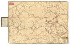
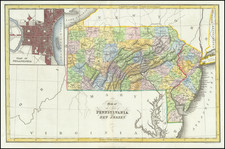
An excellent example of the first state of the first map of Pennsylvania to be published in America, with exceptional provenance of Frederick Augustus, Duke of York, son of King George III.
In this, his magnum opus, Nicholas Scull presents a view of Pennsylvania during the French & Indian War, at a point when there was precious little English settlement west of the Kittatinny Ridge. The counties that would be recognizable to a modern viewer - Lancaster, Chester, York, Bucks, Berks, Cumberland, Philadelphia, etc. - are much enlarged compared to their present-day incarnations; Cumberland itself taking up almost half of the Province. The map is crisscrossed by roads and Indian paths, and the mills, iron forges, furnaces, meeting houses, forts, Indian towns, churches, inns, county-towns, and gentleman's seats that Scull charted become increasingly sparse as one moves west.
The map was based on Scull's own surveys and those of his local contemporaries, but also drew on printed sources, including Fry & Jefferson's map of Virginia, as noted in the lower-left corner:
The Author of this Map, in placing of Fort Cumberland, has followed Fry & Jefferson; but is of Opinion, that whenever the Line is run between Pennsylvania, and Maryland, it will pass to the Southward of that Fort.
The map was a massive production for colonial America; at 60 x 30 inches, it is just over four times the size of Lewis Evans' General Map, which had likewise been published in Philadelphia four years earlier. Scull's map was engraved by James Turner and printed by John Davis, as noted at the bottom center. Little is known about the printer, John Davis. Although he had no shop, he appears to have specialized in large copperplate engravings of maps, as he is the printer identified in the imprint of the 1756 Philadelphia first edition of Joshua Fisher’s important chart of Delaware Bay. That map and the present one are his only known works.
17 years after its publication, in August 1776, the map was one of those hanging on the walls of the Board of War in Philadelphia.
Nicholas Scull II
Scull (1687-1761) was a major American surveyor and cartographer of the Colonial Period. He was born in Philadelphia, to Nicholas Scull (also a surveyor) and apprenticed to William Penn's surveyor, Thomas Holme, at an early age. In 1708 he married Abigail Heap. As of 1730, he was a member of Benjamin Franklin's Junto, and Franklin noted Scull as a book lover and someone who was able to speak the local Delaware Indian language.
Scull's two most notable maps are his 1752 A Map of Philadelphia and Parts Adjacent, and his 1759 To the Honourable Thomas Penn and Richard Penn, Esqrs., true & absolute proprietaries & Governours of the Province of Pennsylvania & counties of New-Castle, Kent & Sussex on Delaware this map of the improved part of the Province of Pennsylvania (the present map).
With his wife Abigail, Scull would have three sons: Edward Scull, John Scull, and Nicholas Scull III, all of whom would become surveyors. The couple also had a daughter, Mary.
State and Rarity
This is the first state, before the addition of text at Nelson's Ferry and the additional road running directly east from Carlisle to Pine Ford.
The last copy we find selling at auction was the Streeter-Welsh-Park-Snider copy, at the Jay Snider Sale, Bloomsbury New York, 2008. That copy brought $96,000. It was subsequently offered in William Reese's The Streeter Sale Revisited, as item 190, for $135,000.
There are less than a dozen known institutional copies.
The Duke of York as a Prolific Map Collector
Frederick Augustus, Duke of York and Albany, (1763-1827), was the second son of King George III, and much like his father, a prolific collector of books and maps. A grand library was a necessity for a gentleman of his standing in Georgian Britain, regardless of his occupation, but as a lifelong military man (eventually Commander-in-Chief of the Forces), it was especially important for the Duke of York.
The Duke collected maps, prints, and books throughout his life. In the 1790s, he commissioned the printseller Holland to gather rare 18th-century satirical prints into a series of albums for him. That collection grew to encompass four albums and several hundred prints. His book collection was larger by several orders of magnitude; when it was finally sold after his death in 1827, it took 22 days (starting on May 7, 1827) for Sotheby's to sell the 5548 lots of books from his library. As the Duke of York was not directly in line for the Crown, his collection did not become part of the Royal Collection.
At the end of the 200-page Sotheby's book sale catalog was an advertisement for the sale of the Duke's over-800-lot map collection:
MAGNIFICENT MAPS AND CHARTS.
The most extensive and invaluable Selection of MAPS and CHARTS, the Property of HIS ROYAL HIGHNESS THE DUKE OF YORK, DECEASED.
Including a Grand Classical Arrangement of "Chartae Geographicae"; or a Collection of Maps and Charts in reference to Ancient and Modern Geography, contained in Eighty-Six [actually Eighty-Eight] Atlas Book-Boxes, 2 feet high by 16 inches wide, uniformly bound and lettered with the Contents.
The Duke of York's Chartae Geographicae Map Collection
The map collection was of vital professional interest to the Duke, as well as an obvious focus of his collecting passion. And the crowning jewel of the map collection was the 88-volume boxed set of maps, each bearing the Duke of York's bookplate (with his coat of arms and "DY") as well as the volume number and map number.
In Harley and Walters' article on early English map collecting, they identified the Duke's boxed-map collection as being the most important from the period:
This item, lot No. 238, was in itself a veritable map library of world-wide proportion. It was cited in the catalogue as 'Chartae Geographicae antiquae et recentiores-Collection-in reference to antient and modern geography, consisting of 5,500 maps, engraved by the early modern geographers, contained in 88 folio Double Book Cases, and properly lettered'. It was sold for £400 to Cochran.
Select maps from the Duke of York's collection have appeared on the market in the last few decades, though we have not been able to trace the actual volumes beyond their sale to Cochran (almost certainly the London bookseller John Cochran) in 1827.
![For Governor, Maj. Gen. John W. Geary [Former Mayor of San Francisco / Governor of Kansas Territory and Governor of Pennsylvania]](https://storage.googleapis.com/raremaps/img/small/93592.jpg)