|
||

|

|
|

|
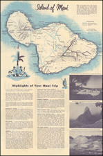
World War II Confidential / Restricted Aeronautical Map of Hawaiian Islands
Detailed aeronautical map of the Hawaiian Islands, compiled by the U.S. Army Air Force Army Map Service.
The map is drawn from US Coast & Geodetical Service Charta and National Geographical Service Maps of the Pacific Ocean, a US Geological Service map of the Territory of Hawaii and other sources, compiled in early 1943.
The front side map illustrates the Hawaiian Islands and Midway Islands on a large scale, with profile recognition views and elevations, prepared to assist long range bombers and other military aircraft with visual navigation of the islands. On the verso is a map of the wider Northwestern Pacific, with the various airfields on the map identified in purple boxes.
A scarce WWII survival.
![(World War II - Jewish Resistance in Poland) ספר מלחמות הגיטאת [Book of the Ghetto Wars]](https://storage.googleapis.com/raremaps/img/small/81013.jpg)