|
||

|

|
|

|
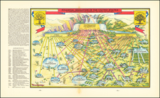
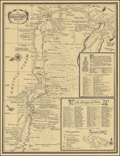
Fine example of Waugh's 1930 pictorial map of Cape Cod and part of the South Shore of Massachusetts including Plymouth, Buzzard Bay, and Duxbury.
Waugh elegantly illustrate important towns and roads, while integrating a host of historical vignettes, most of which pay tribute to the seafaring history of the region.
Ship wrecks and historical events are also noted, including the arrival of the Mayflower. The borders include additional ships, lighthouses and buildings, while the left and right borders include illustrations of famous ships and sea shells.
A columnist in the local weekly writes about Coulton Waugh and this particular map:
Coulton Waugh was the son of noted marine painter Frederick Waugh. The two Waughs differed artistically, yet they shared a love of the sea and were on the best of terms personally. Coulton was a professional sailor and made scale drawings of historic ships, designed fabrics, and made decorative maps and charts…Coulton Waugh was considered to have revived, if not originated the art of decorative map making when he exhibited a large map of silk in 1918 at the International Silk Show in New York City. His map of Cape Cod is one of the most decorative ever prepared. The central cartouche shows the Mayflower and two Pilgrims in armor. The border was reproduced from a drawing cut with a knife in the wood-block technique. The top and bottom borders are of a stylized Cape Cod landscape and the sides borders are decorated with the images of six famous ships. The Rose Dorothea appears in the lower right hand corner.
A nice example of this fine pictorial map.
![[Medieval World Map] Das ist die mapa mudi und alle Land un Kungkreich wie sie ligend in der ganze Welt](https://storage.googleapis.com/raremaps/img/small/102356.jpg)