This item has been sold, but you can enter your email address to be notified if another example becomes available.


|
||

|

|
|

|
Stock# 63115
Description
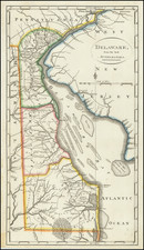
Nice example of Matthew Carey's early map of Delaware, wich first appeared in Carey's American Pocket Atlas in 1796.
A highly detailed map, which includes towns, roads, rivers and many other details.
States of the Map
The map is known in 4 states:
- State 1 (1796):
- State 2 (1801): F. Miflin added on Mud Island. Reedy I. named in the Delaware River, and several additional roads.
- State 3 (1805): New place names include Grubs, Shelpot Cr., Bury R., Glasgow, Red Lion, Hamburg, Buch, Mount Pleasant and others. Duck Creek is relocated to the southwest of Salisbury. New roads added.
- State 4 (1813): The following place names are added in heavier letters: Newcastle, Appoquinimink, Duck Creek, Dover, Mother Kill, Mispillion, Broad Kill, Rehoboth, Little Creek, Baltimore. A few roads added.

![[New Castle, Delaware]. Sandhocken (Fort)](https://storage.googleapis.com/raremaps/img/small/79459.jpg)
![Notes on the State of Virginia [with the map:] A Map of the country between Albemarle Sound, and Lake Erie, comprehending the whole of Virginia, Maryland, Delaware, and Pensylvania, with parts of several other of the United States of America. Engraved for the Notes on Virginia.](https://storage.googleapis.com/raremaps/img/small/55181.jpg)