


|
||

|

|
|

|
Chinese Mariners Discovery of America in the 5th Century!
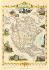
Interesting map of North America, in the interim period between the French & Indian War and the American Revolution.
This map is perhaps most notable for the inclusion of Fou-sang, reflecting the belief that Chinese mariners may have reached America in the 5th Century, AD, establishing the colony of Fou-sang. According to some historians such as Charles Godfrey Leland and Joseph de Guignes ( Le Fou-Sang des Chinois est-il l'Amérique Mémoires de l'Académie des Inscriptions et Belles Lettres, tome 28, Paris, 1761), the distances given by Hui Shen (20,000 Chinese li) would locate Fou-sang on the west coast of the American continent, near British Columbia.
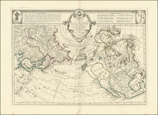
This is also one of the few maps to name the "Sea of Anadir." (Straits of Anian)
The map shows the mythical River of the West, tentatively running from the Rocky Mountains to Puget Sound, searching hopefully for a short portage from the headwaters of several major rivers flowing to the south and east.
Fou-Sang
Eighteenth century mapmakers placed Fou-Sang in North America, typically on the coast of Washington or Vancouver Island. Notable mapmakers, including Guillaume De L’Isle and Antonio Zatta, based their location of the colony on a popular essay written by the French orientalist historian Josepth de Guignes in his 1761 article “Le Fou-Sang des Chinois est-il l’Amérique? ”
Fou-sang is most fully described on by the 6th century itinerant monk Hui Shen. Hui Shen is said to have been a mendicant Gondaran monk and to have appeared in the court of the Emperor Wu Ti at Jingzhou in Southern Qi in 499 AD. His adventures, which are described by Yao Sialian in the 7th century Book of Liang, describes his voyage in both known and unknown lands.
Starting around 455 AD, he traveled to the coast of China, to Japan, Korea, to the Kamchatka Peninsula, then to Fou-sang, some 20,000 Chinese Li (about 9,000 km) east of Kamchatka, somewhere near modern day British Columbia.
While controversial, a number of scholars and historians followed the position that the Chinese not only visited the New World but maintained regular contact with it. The advanced stated of shipbuilding and navigation in ancient China would have meant the Chinese were capable of launching expeditions across the Pacific. Over the past 200 years numerous scholars, both eastern and western, have broken down the Hui Shen text. Some have declared it a fabrication, but others have embraced the idea that the Chinese visited America and maintained a minor but active back and forth communication.


![[ Trans-Atlantic Cable ] Amerique Septentrionale avec l'indication des Principaux Courants marins d'Amerique en Europe](https://storage.googleapis.com/raremaps/img/small/98084.jpg)
![[Pan American Menu Map] North America](https://storage.googleapis.com/raremaps/img/small/103976.jpg)