|
||

|

|
|

|
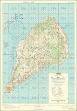
Top-secret Sainte-Mère-Eglise, the first French town liberated on D-Day
A rare “Top Secret” map depicting the area around Sainte-Mère-Eglise, a key Normandy crossroads and the first town liberated during Operation Overlord. The map was issued just weeks before D-Day, and has provenance to the aide-de-camp to U.S. Army Major General Harold W. Blakely (1893-1966), commander of the 4th Infantry Division, which spearheaded the landing at Utah Beach.
This remarkable map depicts a roughly nine-by-six-mile area around Sainte-Mère-Eglise, located just a few miles inland from Utah Beach. Control of the town was key for both preventing German reinforcements and opening the way to a planned advance up the Cotentin Peninsula toward Cherbourg. Its was thus a key objective on D-Day, and it was captured by elements of the 82nd Airborne Division early on the morning of June 6, making it the first town liberated during the invasion. Though badly outnumbered, the 82nd managed to hold out until relieved by ground forces moving inland from Utah on June 8.
The map provided planners and troops on the ground with a staggering amount of information about the natural and man-made landscape. There are of course roads, towns and villages, and contour lines at 10-meter intervals (though these last are to be “accepted with caution”). But—and this is just a sampling—there are also distinct symbols for mud, sand, shingle and dunes; woods, orchards, and brushwood; vineyards, cemeteries and wells; and windmills, windpumps, lighthouses and lights. Regarding military installations, the legend on the back of the map identifies dozens of distinct symbols, including for example fixed coast guns, fixed coast howitzers, mobile guns or gun-howitzers, mobile howitzers, antiaircraft guns, and anti-tank guns; not to mention machine guns (light/medium, open/in turrets), mortars, anti-aircraft machine guns, and flamethrowers.
One controversial element is the use of pink shading to indicate “ground probably soft.” This was a gross understatement: To deter parachute and glider landings, the Germans had in fact flooded miles of farmland behind the invasion beaches. On the day of the invasion, thousands of Allied paratroopers and glider-borne troops, burdened by full combat gear, found themselves mired in natural or man-made swampland.
The map was compiled by Company B of the 660th Engineers, a photo-mapping unit of 300 men plus their officers, based in a London suburb. The unit arrived in England in September 1942, and its first assignment was the daunting task of preparing maps of northwestern France at a scale of 1:25,000. This essentially meant “producing a completely new map,” as the only existing maps were at a scale of 1:50,000 and based on French sources prepared during the Napoleonic era! (Locke, p. 272) For lack of another option, Company B mapmakers settled on a compromise, building their maps from photographic data derived from hundreds (thousands?) of RAF reconnaissance flights, using as control points those established during the Napoleonic triangulation. (Locke 274)
Until recently, the map was in the possession of the stepson of Capt. Roswell F. MacGillivray, aide-de-camp to Major General Harold W. Blakely, commander of the 4th Division. Among MacGillivray’s duties during the Normandy Campaign was to perform reconnaissance and target spotting for the 4th Division Artillery, which landed on Utah Beach with the bulk of the 4th Division on June 6, 1944, and it is highly likely that he consulted this and other maps offered in this sale in the course of these missions (We are pleased to offer a map of the area around the nearby town of Carentan, also with MacGillivray provenance.) Present with the map are photocopies of several documents related to MacGillivray’s service in the 4th.
In all, a rare and richly-informative artifact from one of the most significant, dramatic and terrifying events in the Second World War.
Rarity and references
The map is quite rare. OCLC 829141050 lists holdings at the Univ. of Oregon and Wisconsin Veterans Museum, editions not known. OCLC 704432673 adds examples at the Pritzker Military Museum and Library in Chicago (April 1944 Second Edition) and McMaster University Libraries. The British Library holds an example with a somewhat different color scheme, dated May 20 and bearing the ultra-secret “BIGOT” designation.
For background on Company B of the 660th Engineers, see Maj. J. W. Locke, “Military Photogrammetry in Action in Europe” in Photogrammetric Engineering, vol. XII no. 3 (Sept. 1946), pp. 272-81.
Offered in partnership with Boston Rare Maps.
![(Second World War - First Soviet Breakthrough into Germany) Генеральный Штаб Красной Армии - (Фюрстенвальде) | (Франкфурт) [General Staff of the Red Army - (Fürstenwalde) | (Frankfurt)]](https://storage.googleapis.com/raremaps/img/small/63108.jpg)
![Regionis Biturigum Exactiss: Descriptio Per D. Ioannem Calamaeum [with] Limaniae Topographia Gabriele Symeoneo Auct.](https://storage.googleapis.com/raremaps/img/small/61579.jpg)
![[ France ] Galliae seu Franciae Tabula, qua omnes Provinciae, Viae angiariae, et aliae res notatu dignae distincte et accurate ostenduntur . . .](https://storage.googleapis.com/raremaps/img/small/98436.jpg)