|
||

|

|
|

|
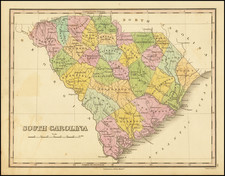
Nice example of the first edition of Mathew Carey's map of South Carolina, published in Carey's American Atlas.
This fine map of South Carolina is the earliest map of the state to be published in the United States in a Commercial Atlas.
Carey's American Atlas was the first atlas published in the United States, compiling a number of excellent maps from indigenous sources in the first compilation of American maps. This map was engraved by Samuel Lewis. It shows remarkable early detail, including towns, the 8 precincts, roads, rivers, lakes, court houses, and a host of other details. The map includes excellent topographical detail, although because of an error, the map is elongated to the North and South. There are boundary errors on the Peedee River and with Georgia. This first state of the map can be distinguished from the second state by the lack of a page number in the upper right corner. An essential map for South Carolina Collectors.
![[ Carolinas & Georgia ] Carte De La Caroline Et Georgie . . .](https://storage.googleapis.com/raremaps/img/small/99744.jpg)
![[ Colonial South Carolina Indenture ] [ Vellum document granting 150 acres of land at the fork of the Saluda and Broad Rivers near present Columbia, South Carolina, to Nicholas Pressler, signed by James Glen, colonial governor of South Carolina ]](https://storage.googleapis.com/raremaps/img/small/103999.jpg)
![(Province of Carolina) [Deed of Sale in Colleton County, Mark Mathew to Jonas Eaton]](https://storage.googleapis.com/raremaps/img/small/92690.jpg)