|
||

|

|
|

|
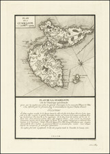
John Byre's Survey of St. Vincent
Rare James Wyld edition of this large map of St. Vincent, published in London, first published by Hooper in London.
The map provides a remarkable depiction of the topographical features of the island, along with a detailed accounting of the Mountainous and Cultivated lands "granted to the Charibs by Late Treaty," The southwestern part of the Island is subdivided among the non-Charibs for auction (numbered to approximately 170 lots), with a large section identified as "Monckton's Quarter," (the lands reserved to the British General and Colonial Administrator Robert Monckton.
The map identifies the land parcels were surveyed in 1764 by John Byres,and thereafter auctioned in England. One very large parcel was omitted from the initial auction because of a prior grant to General Robert Monckton who captured St. Vincent and Martinique,and was given 4,000 acres on the south Windward coast between what is today Biabou Village on the north and Stubbs Village on the south, extending inland to the headwaters of the rivers flowing down the Mesopotamia Valley.
Monckton never settled his land but sold it instead for £30,000. The auction of land earned for the British Treasury £162,854 on the sale of 20,538 acres, an average of £7. 16s per acre.
The map includes a note from Jonathan Byres, Chief Surveyor, explaining the map:
This Plan represents the figure of the Island of St. Vincent whichin Obedience to your Instructions I have laid down by actual Survey and described thereon the Boundaries of all the Lands Sold, Leased, Appropriated or otherwise disposed of by your Board.
The Spaces on the Plan left unnumbered represent the Lands remaining to the Crown which are still undisposed of the greatest part being mountainous and uncultivated.
Below the first section is a certification by William Young, Willaim Hewitt and Robert Wynn describing the different lands and explaining the symbols on the map, concluding with the following note:
The Three Chains round the Coast are also considered by us as appropriated to the use of the contiguous Planter, excepting in Cases where any particular Spot may hereafter be found neceeary for erecting Forts or Batteries in which case His Majesty may erect such Forts or Batteries thereon without paying any Compensation for same.
Rarity
First published in 1776, the edition, with the imprint of James Wyld, is very rare. We cannot locate another example. of the map.
James Wyld Sr. (1790-1836) was a British cartographer and one of Europe’s leading mapmakers. He made many contributions to cartography, including the introduction of lithography into map printing in 1812.
William Faden, another celebrated cartographer, passed down his mapmaking business to Wyld in 1823. The quality and quantity of Faden’s maps, combined with Wyld’s considerable skill, brought Wyld great prestige.
Wyld was named geographer to Kings George IV and William IV, as well as HRH the Duke of York. In 1825, he was elected an Associate of the Institution of Civil Engineers. He was one of the founding members of the Royal Geographical Society in 1830. Also in 1830, his son, James Wyld Jr., took over his publishing house. Wyld Sr. died of overwork on October 14, 1836.
James Wyld Jr. (1812-87) was a renowned cartographer in his own right and he successfully carried on his father’s business. He gained the title of Geographer to the Queen and H.R.H. Prince Albert. Punch (1850) described him in humorous cartographic terms, “If Mr. Wyld’s brain should be ever discovered (we will be bound he has a Map of it inside his hat), we should like to have a peep at it, for we have a suspicion that the two hemispheres must be printed, varnished, and glazed, exactly like a pair of globes.”

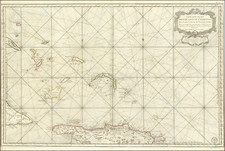
![[ Barbadoes ] Novissima et Acuratissima Barbados. Descriptio per Johannem Ogiluium. Cosmographum Regium](https://storage.googleapis.com/raremaps/img/small/86773.jpg)
![[Turks & Caicos, Bahamas, Hispaniola and Cuba]. Carte Reduite Des Debouquements, De St. Domingue, Levee, Dressee et Publiee par Ordre du Roi . . . 1787](https://storage.googleapis.com/raremaps/img/small/83475.jpg)