|
||

|

|
|

|
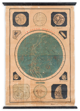
Rare separately published map of the Northern Polar Hemisphere, prepared by Van Luchtenburgh in Rotterdam, with a credit to Cornelis Danckerts as the engraver.
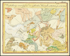
Rare celestial chart by Andreas van Luchtenburg, illustrating the stars of the north equatorial pole down to 40 degrees, illustrated in a polar equidistant projection with external orientation with a diameter of 49cm.
In the borders are four wind heads, and in the top corners are diagrams of the Copernican Solar System and the Earth's orbit around the sun. The title is on a banner held aloft by putti. This plate was originally published by Jacob Robyn c.1688.
Includes a dedication to the Frederick III of the Hohenzollern dynasty, Elector of Brandenburg (1688–1713) and Duke of Prussia, who would become Frederick I of Prussia. The latter function he upgraded to royalty, becoming the first King in Prussia (1701–1713). He was also the paternal grandfather of Frederick the Great. The dedication reads: Frederico Tertio deo gratio Marcii Brandenburgi Prussiae, Magdeburgi Iuliae, Cliviae, Montium Pomeraniae & Luxci, nec non S.R. delectori et archicamerario. Cornelis Danckerts exec. . . .
![Hemisphere Austral [and] Hemisphere Boreal](https://storage.googleapis.com/raremaps/img/small/81984.jpg)