This item has been sold, but you can enter your email address to be notified if another example becomes available.


|
||

|

|
|

|
Stock# 62764
Description
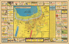
Lively pictorial map of Michigan, published by the Historical Society of Michigan in 1952.
The map shows primary cities, towns and points of interest throughout the state, ports, sounds, railroads, rivers and forests.
The map is richly embellished with vignettes depicting landmarks, ships, boats, woods, lumber industries, wildlife, historical figures and events and Native American settlements.
The decorative cartouche in bottom is adorned with pirates, a lumber Jack, Native Americans, a train, an early car, and the seal of Historical Society of Michigan at the top.
The artist, Frank Barcus, also created a map of Downtown Detroit in 1945.