


|
||

|

|
|

|
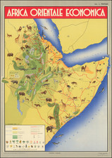
Italian Imperial Aspirations in East Africa -- Economic Opportunities
Detailed, color-printed pictorial wall map of Italian East Africa, published by Officien Grafiche S.A. Parini Vanoni & C. for the Banca Populare di Milano in 1936, the year the colony was established.
Interesting vintage thematic map poster.
The map focuses on the natural resources, agricultural products, and mineral production opportunities in the region, including:
- Gold & Silver
- Diamonds
- Petroleum
- Pearls
- Incense
- Coffee
- Sugar
- Wheat
- Tobacco
- Cotton
Italian East Africa
Italian East Africa was an Italian colony established in 1936, consolidating preexisting Italian territories in East Africa with the newly-conquered Empire of Ethiopia.
As is shown on the map, the Italians quickly assumed the imperial trappings of the Empire of Ethiopia; here Vittorio Emanuele III is called "King of Italy and Emperor of Ethiopia" and Pietro Badoglio is "Duke of Addis Abeba". These titles were not recognized outside of Italy, Nazi Germany, and Japan.
The map illustrates the subsidiary divisions of the colony: Somalia, Arrar, Galla-Sidamo, Addis-Abeba, Amhara, and Eritrea.
The colony would be expanded in 1940 with the conquest of French Somalia and British Somalia. In 1942, British and South African forces had captured most of the colony, though an Italian guerrilla campaign continued into the next year.
![Tabula Aphricae II [Sicily & Sardinia shown]](https://storage.googleapis.com/raremaps/img/small/89727.jpg)
![[ The Search for the Source of the Nile ] Nouvelle Carte du Bassin du Nil indiquant la commune origine de ce Fleuve avec les Rivieres du Zanguebar Dressee et Dediee A La Colonie Europeene D'Orient . . . 1858](https://storage.googleapis.com/raremaps/img/small/96196.jpg)