


|
||

|

|
|

|
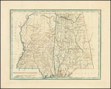
Early map of Mississippi and Alabama, which until about 15 years earlier had comprised a single territory.
The eastern part of Alabama is still the lands of the Creek and Cherokee Indians and a number of counties are still not present. The Northern half of Mississippi is dominated by oversized counties and Indian Lands. Includes early towns, counties, rivers and other points of interest.
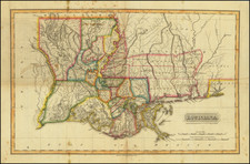
Princeton or N. Mexico appears in Washington Parish. Several Indian Villages located.
Thomas Gamaliel Bradford (1802-1887) was an American geographic publisher. He hailed from Bradford, Massachusetts and began his publishing career by working for the America Encyclopedia. Then, he edited and republished the Atlas Designed to Illustrate the Abridgement of Universal Geography, Modern & Ancient, which had originally been offered in French by Adrian Balbi. In 1835, he published another atlas, A Comprehensive Atlas: Geographical, Historical & Commercial, and, in 1838, An Illustrated Atlas Geographical, Statistical and Historical of the United States and Adjacent Countries. His interests were primarily in educational publishing and he was one of the first mapmakers to show Texas as an independent country.

![[Louisiana / British Emigration -- 5 Maps] Land District North of the Red River in the State of Louisiana / District North of the Red River Louisiana / Land District North of the Red River, State of Louisiana / Township 20 N. Range 13 East, Land District North of the Red River in the State of Louisiana / A Map, exhibiting the order oft he Surveys of the Public Lands of the United States of North America . . . .](https://storage.googleapis.com/raremaps/img/small/90084.jpg)