|
||

|

|
|

|
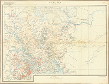
Rare Hanoi Imprint of French South Vietnam -- First Railroad Line In Vietnam Illustrated
Finely executed map of South Vietnam and part of Cambodia, published in Hanoi for the French Colonial Government.
The map provides a highly detailed accounting of the roads in the region, with three different symbols in red noting the quality of the roads (double line, single line and xx's).
The Vinh-Te Canal is shown, as is Vietnam's first railroad line from Saigon to Cholon and My Tho, which had been constructed between 1881 and 1885, with the final bridge finished only a few years earlier (May 1886).
The map was published by F.H. Schneider in Hanoi, one of the earliest maps printed in Hanoi.
The legend at the bottom left notes:
Dressee par Mr. le Capitaine Friquegnon, d'apres les Cartes marines, les Travaux du Service du Cadastre et des Officiers
(Prepared by Mr. Captain Friquegnon, from Nautical Charts, the Works of the Cadastral Service and the Officers)
The map credits Captain Jean-Baptiste Friquegnon (1858-1934) as its source. The Bibliotheque National de France credits Captain Friquegnon with 14 maps of various parts of Vietnam and Indochina between 1889 and 1914). The present map is not one of the 14 listed maps.
Saigon-MyTho Railroad
The first regional raiilroad was built between 1881 and 1885, between Saigon and My Tho, a distance of abut 44 miles. The Saigon–My Tho line was originally proposed in 1880 by Charles Le Myre de Vilers, Governor of Cochinchina from 1879 to 1882, as part of a plan for a railway linking Saigon and Vinh Long, with a northwestern line continuing on to Long Xuyen, Chau Doc and Phnom Penh, and a southwestern line to Can Tho, Soc Trang and Bac Lieu. However, only the Saigon-My Tho line was completed.
Eyraud de Vergnes, chief engineer for Cochinchina's Department of Public Works, was charted with planning the railway, with construction coordinated by a French engineer named Joret. Construction of the line was marred by conflicts between Joret and Charles Thomson, who was appointed Governor of Cochinchina in 1883; as a result, the line was incomplete upon inauguration on July 20, 1885, missing a railway bridge at Ben Luc. Although the new service was well received, passengers were required to disembark at Ben Luc and cross the Vam Co Dong River by boat; the bridge was finally completed in May 1886, allowing travel straight through to My Tho, which reduced travel time between the two cities from 12 hours to only 3 hours, and established a connection between Saigon and the shipping lanes of the Mekong Delta.
Vinh-Te Canal
The Vĩnh Tế Canal is a 54 mile canal in southern Vietnam, designed to give the territory of Châu Đốc a direct access to the Hà Tiên sea gate, in the Gulf of Siam.
After the construction of Thoại Hà Canal, Emperor Gia Long of Nguyễn Dynasty ordered the mandarin Nguyễn Văn Thoại to dig a new canal along the Cambodian–Vietnamese border. The construction of the canal was started in the end of 1819. After the death of Emperor Gia Long, the succeeding Emperor Minh Mạng continued the project. The workers, especially the Khmers, were heavily exploited by being forced to do hard work, which resulted thousands of death. Consequently, the Vinh Te Canal became a symbol of Vietnamese mistreatment of the Khmer and was used later by the Khmer Rouge in anti-Vietnamese propaganda.
The construction was completed in 1824 and Emperor Minh Mạng named the canal after Châu Vĩnh Tế, the wife of its builder Nguyen Van Thoai. From that point on, the canal plays an important role in the southern Vietnam's communication, transportation and the definition of the border of Vietnam and Cambodia
Rarity
The map is very rare. OCLC locates 1 example of the 1890 edition (British Library) and 2 examples of the 1889 edition (Bibliotheque National & University Strassbourg and Bibliotheque National de France).