|
||

|

|
|

|
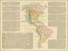
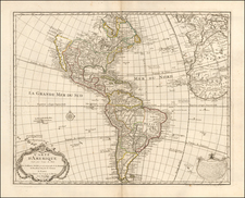
Scarce map of America, published by Felix Delamarche in Paris in 1823.
The map presents an interesting look at North and South America at a time of great change and intrigue on both continents. This is during the height of South America's revolutionary decades when Simon Bolivar and others were liberating the continent from Spanish Colonial rule, while North America seeing the independence of Mexico and the great domestic rush to explore the western and northern reaches of the continent.
Mexico has just gained its independence and Louisiana is now part of the United States. Russian America is clearly labeled, with MacKenzie's discoveries in 1789 noted, along with Hearne's discovery of the Polar Sea connection to the Hudson Bay Company lands in 1771.
The uncertain boundary between Oregon Territory and British America west of the Rocky Mountains is shown with a serpentine boundary line that puts all of Puget Sound in British hands, a very un-French depiction for the period.
Lake Timpanogos and Lac Sale are still shown, with curiously depicted New Albion showing the regions still theoretically claimed by the English as a result of Sir Francis Drake's discoveries in the 16th Century.
A good accounting of Lewis & Clark's discoveries is given, including a note showing Fort Clatsop, where Captain Lewis hibernated in 1805.