This item has been sold, but you can enter your email address to be notified if another example becomes available.


|
||

|

|
|

|
Stock# 62427
Description
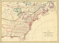
Rare map of North America, published by Weigel in Nuremberg.
The map is based upon Guillaume De L'Isle's map of North America from 1700, with the addition of a large plan of Halifax, Nova Scotia and its fortifications.
The map shows a peninsular California with C. Mendocin as the farthest northern point on West Coast. The English settlements are confined east of the Alleghenies with Carolina shown as a French colony.
The Mississippi River valley is well developed with recent French settlements located. The interior is filled with the names of various Indian nations.
The map is exquisitely adorned with two large vignette-style cartouches depicting Native Americans and exotic animals.

![(North America) ПОЛИТИЧЕСКАЯ КАРТА СЕВЕРНОЙ АМЕРИКИ. [Political Map of North America]](https://storage.googleapis.com/raremaps/img/small/90261.jpg)