|
||

|

|
|

|
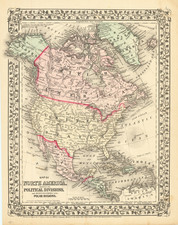
Blue Dot For Fort Ross, California -- Part of Russian Territory
Nice example of Brue's map of North America, published in Paris in 1840
Excellent map of North America and the West Indies. Beautifully engraved on fine heavy paper with the embossed atlas seal of the publisher below the script title. Alaska is named as Amerique Russe and is still a bit misshapen, with a blue dot at Point Bodega, showing the location of the Russian Fort Ross.
Texas is shown as a Republic, with the Adams-Onis boundary with Mexico shown.
The individual state and territorial borders are shown up to the Mississippi River, with a large Arkansas Territory extending above Texas.
Andre Hubert Brué was a French geographer and cartographer. Born in Paris, he served in the French Navy, joining the Baudin expedition to the Pacific (1800-1804). After his sea service, Brué applied his navigation and charting skills to creating finely-crafted maps, which were renowned for their crisp engraving and accuracy. He drew directly on the copper of the plate, creating what he called encyprotypes. He is best known for the Atlas universal de géographie physique, politique, ancienne et moderne.
![[Signed Political Satire Artwork] Vietnam ... Vietnam ... Vietnam ...](https://storage.googleapis.com/raremaps/img/small/68726.jpg)