This item has been sold, but you can enter your email address to be notified if another example becomes available.


|
||

|

|
|

|
Stock# 62382
Description
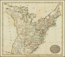
Nice example of Flemming's map of the United States, exhibiting in fabulous detail the early US territorial borders, Indian Districts, Forts, early routes of the Transmississippi explorers and other details.
Many Indian tribes, forts, missions, roads, and other details. Includes a very unusual tomahawk shaped Indian Territory and massive Minnesota and Missouri Territories. Excellent topographical details, some real, some conjecture.
Pre-Gadsden Purchase atlas map, which predates the split of Oregon Territory into Oregon and Washington, but shows both Utah and New Mexico, indicating that it was issued sometime around 1850.

![[Grateful Dead Tour Poster] The Original Grateful Dead Wall Map & Tour Guide Volume 1 / The Golden Road To Unlimited Devotion](https://storage.googleapis.com/raremaps/img/small/85630.jpg)