


|
||

|

|
|

|
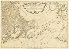
Rare D'Anville Map of Northwest Pacific Showing the Discoveries of the First Kamchatka Expedition
Fine example of this important early map of Kamchatka and Japan, showing the sea route of the First Kamchatka Expedition. It also details the fanciful islands of Yesso and Company’s Land.
D’Anville’s map shows the entirety of Japan and much of eastern China. However, the focus of the map is farther north and east, on a massive Kamchatka Peninsula and the islands northeast of Japan. Political subdivisions are marked with dotted lines, while towns and cities are indicated with building symbols. Waterways are emphasized, with mountains scattered across the countryside.
D’Anville has included many notes, which increase as the reader looks to the north. Most of the notes are ethnographic annotations that discuss indigenous peoples’ relation to the Russians and whether or not they are tributaries of the Russians.
A simple set of four scale bars is tucked into the interior of Russia. In the waters to the southeast of Japan is an ornate cartouche containing the title and some information about sources used to make this map. A torch sites atop floral scrollwork, trumpeting the potential of these lands. The long title mentions the discoveries of the Russians, a reference to the recently-completed First Kamchatka Expedition, as well as the mysterious Terre de Jesso.
Chimerical islands in the North Pacific
In addition to the mention of Yesso in the title cartouche, a note in the long Kamchatka peninsula reads, “Les Kurilski qu on croit Colonies du Japon connus sous le nom de Terre de Jeso.” This translates to, “The Kurils which are believed to be colonies of Japan known by the name Terre de Jeso.”
D’Anville has constructed a particularly interesting depiction of Yesso, also known as Jesso or Jeso, a feature included on many seventeenth and eighteenth-century maps. Historically, Eso (Yeco, Jesso, Yedso, Yesso) refers to the island of Hokkaido in northern Japan. It varies on maps from a small island to a near-continent sized mass that stretched from Asia to Alaska.
Here, D’Anville has connected not only Hokkaido, but also the Kuril Islands to the Kamchatka Peninsula. This formulation was after the work of Jacques-Nicholas Bellin, another prominent French mapmaker who worked for the Depôt de la Marine as a hydrographical engineer.
Another hypothetical island is also included here, Terre de la Compagnie, whose addition to maps stretches back to mid-seventeenth century. In the sixteenth century, Juan, the grandson of Vasco de Gama, was a Portuguese navigator who was accused of illegal trading with the Spanish in the East Indies. Gama fled and sailed from Macau to Japan in the later sixteenth century. He then struck out east, across the Pacific, and supposedly saw lands in the North Pacific.
Several voyagers sought out de Gama’s lands, including the Dutchmen Matthijs Hendrickszoon Quast in 1639 and Maarten Gerritszoon Vries in 1643. Vries commanded the Castricum, while Hendrick Cornelisz Schaep was in charge of the Breskens. Compagnies Land, along with Staten Land, were islands sighted by Vries on his voyage. He named the island for the Dutch States General (Staten Land) and for the Dutch East India Company (VOC) (Compagnies, or Company’s Land). In reality, he had re-discovered two of the Kuril Islands. However, other mapmakers latched onto Compagnies Land in particular, enlarging and merging it with Yesso.
Here, D’Anville has included both Staten Land (I des Etats) and Compagnies Land (Terre de la Compagnie), separated from Kamchatka/Yesso by the Strait of Uries. This is a derivation of the Dutch navigator’s name, Vries.
The First Kamchatka Expedition
A dotted line rounds the north of Kamchatka; this is a voyage that was part of the First Kamchatka Expedition, Russia’s first scientific exploratory voyage. Peter I ordered the expedition to verify if there was a strait between Asia and America in 1724. Led by Vitus Bering, his men struggled overland for two years from Saint Petersburg to Okhotsk.
In 1728, the Fortuna and the Vostok sailed north and then east. Eventually, they passed through what is now called the Bering Strait to the Chukchi Sea. Although it did not reach North America, it did prove that the continents were not connected.
The route shown here is not an exact representation of the ships’ voyage, but this is because the French were not privy to extensive information about the voyage. The Russians were keeping the information clandestine, as much as possible, until they completed a Second Kamchatka Expedition, also commanded by Bering.
This is an early representation of the expedition’s findings and an intriguing configuration of the North Pacific, which was of increasing interest to Europe in the mid-eighteenth century.
Rarity
The map is very rare on the market. OCLC locates only a single example in the Bibliotheque Nationale de France: https://catalogue.bnf.fr/ark:/12148/cb40667054c
We find no examples offered in dealer catalogs or auctions in the past 30 years.
Jean-Baptiste Bourguignon d’Anville (1697-1782) was one of the foremost French geographers of the eighteenth century. He carried out rigorous research in order to create his maps, which greatly developed the technical proficiency of mapmaking during his lifetime. His style was also simpler and less ornate than that of many of his predecessors. It was widely adopted by his contemporaries and successors.
The son of a tailor, d’Anville showed cartographic prowess from a young age; his first map, of Ancient Greece, was published when he was only fifteen years old. By twenty-two, he was appointed as one of the King’s géographes ordinaire de roi. He tutored the young Louis XV while in the service to the Crown. However, royal appointment did not pay all the bills, so d’Anville also did some work for the Portuguese Crown from 1724. For example, he helped to fill out Dom João V’s library with geographical works and made maps showing Portugal’s African colonies.
D’Anville disapproved of merely copying features from other maps, preferring instead to return to the texts upon which those maps were based to make his own depictions. This led him to embrace blank spaces for unknown areas and to reject names which were not supported by other sources. He also amassed a large personal map library and created a network of sources that included Jesuits in China and savants in Brazil. D’Anville’s historical approach to cartography resulted in magnificently detailed, yet modern and academic, maps. For example, his 1743 map of Italy improved upon all previous maps and included a memoir laying out his research and innovations. The geographer also specialized in ancient historical geography.
In 1773, d’Anville was named premier géographe de roi. In 1780, he ceded his considerable library to the Ministry of Foreign Affairs to be used for as a reference library for diplomats. D’Anville is best known for several maps, including his map of China, first published in 1735, and then included with Du Halde’s history of that country (the Hague, 1737). His map of Africa (1749) was used well into the nineteenth century.
![[Hong Kong / Macao / Canton] Asie No. 98. Partie de La Chine](https://storage.googleapis.com/raremaps/img/small/64115.jpg)
![[ Pacific Ocean and America -- The West Indies ] Descripcion De Las Yndias Ocidentales](https://storage.googleapis.com/raremaps/img/small/95683.jpg)