|
||

|

|
|

|
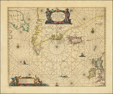
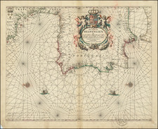
Early Dutch Sailing Chart of the Canary Islands
Rare sea chart showing Canary Islands, showing the islands of Lanzarote, Fuerteventura, Palma, Ferro, Gomera, Tenerife and Gran Canaria.
The chart appeared in J Blaeu's Het Licht der Zee-vaert , first published in 1608.
The charts for this atlas are titled in both Dutch and French and are extremely rare. This is the only example of the chart we have seen on the market in more than 20 years.
Willem Janszoon Blaeu (1571-1638) was a prominent Dutch geographer and publisher. Born the son of a herring merchant, Blaeu chose not fish but mathematics and astronomy for his focus. He studied with the famous Danish astronomer Tycho Brahe, with whom he honed his instrument and globe making skills. Blaeu set up shop in Amsterdam, where he sold instruments and globes, published maps, and edited the works of intellectuals like Descartes and Hugo Grotius. In 1635, he released his atlas, Theatrum Orbis Terrarum, sive, Atlas novus.
Willem died in 1638. He had two sons, Cornelis (1610-1648) and Joan (1596-1673). Joan trained as a lawyer, but joined his father’s business rather than practice. After his father’s death, the brothers took over their father’s shop and Joan took on his work as hydrographer to the Dutch East India Company. Later in life, Joan would modify and greatly expand his father’s Atlas novus, eventually releasing his masterpiece, the Atlas maior, between 1662 and 1672.
![[Portugal] Pascaarte vande Zeecusten van Portugal tusschen de Barlenges en de C. de S. Vincente geleghen, vertoonende nae't leven de ware geleghentheijt vande vermaerde Riviere van Lisbona . . .](https://storage.googleapis.com/raremaps/img/small/52231.jpg)