This item has been sold, but you can enter your email address to be notified if another example becomes available.


|
||

|

|
|

|
Stock# 62170
Description
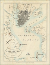
Finely executed sea chart of the area around Charleston Harbor, prepared for the American Coast Pilot.
Charleston is shown in the top left, with a meticulous illustration of the soundings, rivers, shoals, islands, forts and topographical features of the region.
The various channels are illustrated at the right, with a number of lighthouses also shown.
![[Carolina]](https://storage.googleapis.com/raremaps/img/small/89687.jpg)
![Gray's New Map of North Carolina and South Carolina [Charleston Harbor Inset]](https://storage.googleapis.com/raremaps/img/small/98362.jpg)