|
||

|

|
|

|
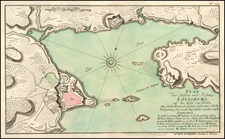
Rare First State of Ince's View of Louisburg at the Time of its Siege in 1758
Fine engraved view, based upon a drawing on the spot by Captain Charles Ince of the 35th Regiment and engraved by Canot.
Captain Ince's view depicts the arrival of the British contingent to set up their artillery. Louisbourg’s Island Battery is partly hidden by the lighthouse, though a puff of smoke indicates French cannon fire. The view illustrates the French stronghold at Louisbourg, with the British ships in Gabarus Bay in the distance, with a British forward position shown. The French Fleet is shown in the harbor, with a French Battery in the mouth of the bay and lighthouse in the foreground.
This is the rare first edition, pre-dating the imprint of John Bowles in 1768.
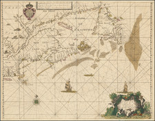
This is one of a series of six views of remarkable places in the Gulf and River of St. Lawrence, commemorating the British successes in the Seven Years War (French & Indian War). Each was drawn on the spot and juxtaposed the British forces against dramatic Canadian landscapes. The complete set includes:
- A View of the City of Quebec, the Capital of Canada. Taken partly from Pointe des Peres, and partly on board the Vanguard Man of War.
- A View of the Fall of Montmorenci and the Attack made by General Wolfe.
- A View of Cape Rouge or Carouge, Nine Miles above the City of Quebec.
- A View of Gaspe Bay, in the Gulf of St. Lawrence.
- A View of Miramichi, a French Settlement in the Gulf of St. Lawrence.
- A View of the Pierced Island, a remarkable Rock in the Gulf of St. Lawrence.
The Siege of Louisbourg
The Siege of Louisbourg in June 1758 was the turning point in the Seven Years War (French & Indian War). Louisbourg was an essential naval fortress for French Canada, strategically located to protect the important French Fisheries in the Grand Banks and the entrance to the St. Lawrence River. In February 1758, despite a string of defeats, British Secretary of State William Pitt stressed the importance of taking Louisbourg.
By June 1, 1758, the British had amassed a large force of 150 ships and 13,000 soldiers to mount an attack on Louisbourg. Brigadier General James Wolfe led the first assault on June 8, 1758, establishing a small landing point near Cap du Rouge. Over the next 49 days, the British consolidated their gains and gradually overtook the Bay and environs. After 10 days of heavy bombardment, the French surrendered Louisbourg, giving the British a stronghold in North America and renewed British spirits, one of the turning points in the war.
Rarity
The view is extremely rare in the first state. We locate no other examples on the market in many decades.
The American Art Association offer a complete set of the six views for sale on February 14, 1928 (Lot 86), in The Notable Library formed by the late Col. Rhinelander Waldo of New York City. Another set was offered by Maggs in 1915 (Catalog 334-859) for the princely sum of 52.10 GBP.
Provenance
Ombersley Court, Worcestershire, United Kingdom; Sold by the Trustees of the Sandys Trust at Sotheby's London, 14 May 2019, Lot 61.
Thomas Jefferys (ca. 1719-1771) was a prolific map publisher, engraver, and cartographer based in London. His father was a cutler, but Jefferys was apprenticed to Emanuel Bowen, a prominent mapmaker and engraver. He was made free of the Merchant Taylors’ Company in 1744, although two earlier maps bearing his name have been identified.
Jefferys had several collaborators and partners throughout his career. His first atlas, The Small English Atlas, was published with Thomas Kitchin in 1748-9. Later, he worked with Robert Sayer on A General Topography of North America (1768); Sayer also published posthumous collections with Jefferys' contributions including The American Atlas, The North-American Pilot, and The West-India Atlas.
Jefferys was the Geographer to Frederick Prince of Wales and, from 1760, to King George III. Thanks especially to opportunities offered by the Seven Years' War, he is best known today for his maps of North America, and for his central place in the map trade—he not only sold maps commercially, but also imported the latest materials and had ties to several government bodies for whom he produced materials.
Upon his death in 1771, his workshop passed to his partner, William Faden, and his son, Thomas Jr. However, Jefferys had gone bankrupt in 1766 and some of his plates were bought by Robert Sayer (see above). Sayer, who had partnered in the past with Philip Overton (d. 1751), specialized in (re)publishing maps. In 1770, he partnered with John Bennett and many Jefferys maps were republished by the duo.