This item has been sold, but you can enter your email address to be notified if another example becomes available.


|
||

|

|
|

|
Stock# 62157
Description
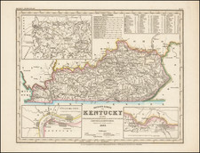
Scarce 1857 Desilver map of Kentucky, hand colored by county and showing towns, rivers, lakes, railroads, roads, distances, forts, etc.
Tables of Steam Boat routes and distances.
Large insets of area around Lexington, the Washington and Clarksburg area and the Falls of Ohio, including Jeffersonville, Louisville, Shippingport and Portland.
A nice example of this increasing difficult to obtain pre-Civil War map.
![[Shows Franklinia!] Charte Der XV Vereinigten Staaten von Nord-America Nach Murdochischer Projection . . . F.G. Gussefeld . . . 1804](https://storage.googleapis.com/raremaps/img/small/91386.jpg)