|
||

|

|
|

|
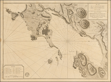
The First Chart of the St. Lawrence River -- Jean Deshayes
Second printing the first sea chart of the St Lawrence River, surveyed and drawn by Jean Deshayes and published by Nicolas De Fer in Paris (bearing the imprint of Deshayes (bottom left) and De Fer (bottom right).
The map extends from Quebec to Anticosti and southward to the Bay of Chaleur and includes six inset maps, including a continuation of the river to Lake Ontario.
In August 1685, Jean Deshayes arrived in Quebec, having been appointed by the French Government to make a hydrographic survey of the St. Lawrence River. Upon his arrival, he first accompanied Governor Brisay de Denonville on a journey up river to Fort Frontenac, at the mouth of Lake Ontario, landing at frequent intervals to observe and calculate latitudes. Upon returning to Quebec, Deshayes consulted with local navigators and explorers, including Louis Jolliet, to develop a strategy for the remainder of the survey. He traveled by snowshoe to establish his baselines and conduct initial triangulations, before departing in a bark with a crew of seven, spending the next six months surveying the river.
During this 6 month period, he was fully occupied in carrying out a detailed hydrographic survey of the St Lawrence below Quebec. In November 1686, he left the colony without completing the survey. In 1699, Deshayes submitted a manuscript version of his map of the St. Lawrence to the Académie Royale des Sciences. Following its endorsement, a printed version of the map was created by 1702, followed by a second edition of the map, with minor alterations, which was likely printed in 1715.
The first state of the map was untitled and carried only Deshayes name at the bottom left. The map included separately printed text panels on either side of the map, with the left text panel bearing a title:
Carte marine de l'embouchure de la rivière de S. Laurens, levée de cap en cap jusqu'à Québec Verifiee par plusieurs Observations. Avec les Dondes & les Remarques pour les Pasages de sujetion. Plus le cours de cette Riviere au dessus de Quebec jusqu'au Lac Ontario. Par le Sieur Des Hayes Hydrographe
There has been wide disagreement regarding the date of publication of the first state of the map. The following is provided by Professor J.S. Pritchard, in Early French Hydrographic Surveys in the Saint Lawrence River, International Hydrographic Review (Monaco), LVI, January 1979.
Deshayes’ [manuscript] chart did not remain in the [French] naval archives. About fifteen years after he had returned to France his chart was published; it was the first printed chart of the St. Lawrence River and one the finest examples of marine cartography of any area in the world outside Europe. Several publication dates ranging from 1686 to 1715 have been suggested, but none are based on the following evidence.
In April, 1699, Deshayes requested permission to publish his chart from the Secretary of State for the Navy, who in turn asked the Royal Academy of Sciences to assess its accuracy. The Academy quickly gave the chart its imprimatur, and in June Deshayes received royal permission to engrave and publish his “ marine chart ” whenever he judged the time appropriate. Sometime afterwards, most likely sooner than later, Deshayes’ chart was published in Paris by Nicolas de Fer. The chart probably appeared before the end of 1702 when Deshayes was appointed Professor of Hydrography at Quebec with an annual stipend of 400 livres.
The published chart is also noteworthy for the very full sailing directions printed in the wide margins. They were chiefly the work of Pierre Lemoyne d’ Iberville during the 1690’s and their appearance filled a much-needed requirement for safer navigation in the St. Lawrence.
As noted by Professor Pritchard above, the Royal Academy of Sciences made the following written report concerning its findings on Deshayes map in 1699 (Histoire de L'Academie Royal Des Sciences, Annee M. DC XCIX at p 85):
M. des Hayes , qui avoit déja fait des voïages de long cours, & un grand nombre d'observations , pour perfectionner la Géographie , aïant été envoie par le Roi en Canada dans le même dessein, en a rapporté une Carte Marine de fa façon , qui comprend le cours de la Rivière de S. Laurent, depuis son embouchure jusqu'au Lac Ontario. II demanda au Roi un Privilège pour la publication de cette Carte , & Sa Majesté fit l'honneur à l'Académie de la lui renvoyer à examiner. L'Académie l'a jugée fort exacte, & d'une grande utilité pour la Navigation de la Rivière de S. Laurent.
Translation: M. des Hayes, who had already made long journeys, and a great number of observations, to perfect the Geography, having been sent by the King to Canada for the same purpose, has brought back a Marine Chart in a fashion which includes the course of the St. Lawrence River from its mouth to Lake Ontario. He asked the King for a Privilege for the publication of this map, and his Majesty did the Academy the honor of sending it to the Academy for examination. The Academy has judged it very exact, and of great utility for the Navigation of the St. Lawrence River.
Based upon our survey of the extent copies of the map, there appear to be 2 states of the map itself, which can be quickly differentiated by the existence of the title of the map in the second state of the map placed in the St. Lawrence River, but absent in the first. Other changes added to the second state include:
- The inset maps now all have heavy outer neatlines
- Inset F adds the title Riviere de Canada ou de St. Laurens
- A G is added below the S in Monts Pelez
- Below Quebec, in the continuation map of the St. Lawrence, a note is added "Ce morceau Q. V. et sur la meme Echelle quel la grande Carte".
- De Fer imprint added at bottom right
- Inset L adds the title Riviere de Canada ou de St. Laurens
The substantial confusion regarding the states of the map by prior bibliograhers is probably caused by the existence of 3 different sets of text panels which may be found with the map. In the first state only, there are side panels as described above. With the second state, the map can either be found without text panels, or with a new set of text panels BELOW the map, bearing the title "De La Grande Riviere De Canada appellee par les Europeens De St. Laurens". This second set of text panels can be found in two states. one bearing the imprint of De Fer and the date of 1715 and a second bearing the imprint of J.F. Bernard and the date of 1715.
While sources vary widely on the publication dates of the various editions, we believe that circa 1702 and 1715 are the correct dates for the two states of the map.
Rarity
All states of the map are very rare.
OCLC locates 2 copies of the first state (Carte Marine) : British Library (dated as 1695), Bibliotheque National de France (dated as 1706).
OCLC locates 7 copies of the second state (La Grande Riviere de Canada): Bibliotheque National de France (dated as 1700s? and a second example dated 1685), Library of Congress (dated 1715 and attributed to JF Bernard, although no date or Bernard attribution appears on the map), McGill (dated 1715), University of Michigan/Clements (1715, De Fer imprint), Amsterdam Library (1695, De Fer imprint), British Library (1715, De Fer).
OCLC locates 1 copy of a second state, with the new text (including a title "De La Grande Riviere de Canada Appellee par les Europeens de St. Laurens" below the map and the De Fer imprint, dated 1715 at the end of the text, but otherwise identical to the second state (Libary of Congress).
OCLC locates 1 copies of a second state, with the same text as state three (including a title "De La Grande Riviere de Canada Appellee par les Europeens de St. Laurens" below the map and the JF Bernard imprint, dated 1715 at the end of the text, but otherwise identical to the second state (Bibliotheque National de France).
We were unable to locate any examples of the first state of the map at auction or in dealer catalogs and only 2 complete copies of second state (De Fer, no date) in the past 50 years. Goodspeed catalogued an example of the De Fer/Text Panel state in a 1929 catalog, likely the copy at the Library of Congress, which contains the same damage as described by Goodspeed (Catalog 180-c28).
The Dictionary of Canadian Biography notes:
DESHAYES, JEAN (he sometimes signed Deshaies), marine surveyor and royal hydrographer of New France . . .
. . . in 1668 Jean Deshayes was already a man of recognized ability. In that year Colbert wished to buy the secret of a new method of calculating longitude from a foreign scholar, and it was Deshayes who was ordered to test its validity. Two years later he departed for Acadia to test a similar theory at sea. . . . The engineer Saint-Columbe described him as “a man of strong good sense.” Deshayes occupied himself with teaching and navigational problems in France until 1681 when, along with two other scientists, he was ordered to undertake an expedition to Gorée off Cape Verde and to the islands of Martinique and Guadaloupe in the West Indies. It was probably as a result of this venture that he was sent to New France to make a hydrographic survey of the St Lawrence River.
He arrived in Quebec in August 1685 and . . . accompanied Governor Brisay de Denonville on a journey to Fort Frontenac (Cataracoui, now Kingston, Ont.), landing at frequent intervals to observe and calculate latitudes and to draw a map. During the next year, he was fully occupied in carrying out a detailed hydrographic survey of the St Lawrence below Quebec. In November . . . he left the colony without completing the survey. Nevertheless, this work became the basis for a chart of the river that was published around 1700 on the recommendation of the Académie Royale des Sciences; a second edition appeared in 1715. These charts were the first engraved maps devoted solely to the St Lawrence River. . . .
It was probably because of the appearance of this chart rather than by any influence exerted on his behalf, that Deshayes was appointed royal hydrographer of New France in 1702. He arrived back in the colony that same year, and for the next four years taught navigation and pilotage to the youth of the colony. In 1703, he was appointed deputy engineer. During the following year, he drew a chart of the north shore of the St Lawrence to show Augustin Le Gardeur de Courtemanche’s voyage of exploration to Labrador.
. . . Besides being the author of a very significant chart, Deshayes published a revised edition of L’Usage du compas de proportion de D. Henrion (Paris 1681; second edition, 1685). He also wrote La théorie et pratique du nivellement, which appeared in 1685, with a second edition in 1695.