This item has been sold, but you can enter your email address to be notified if another example becomes available.


|
||

|

|
|

|
Stock# 62116
Description
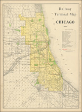
A Large, Early Wall Map of Chicago in Original Van Vechten Binding
Fine early map of Chicago, one of the earliest large maps of Chicago.
The map notes that it was "Drawn from Davie's Atlas with the latest Subdivisions by W.L. Flower and J. Van Vechten," and "Revised, Published & sold by James van Vefchen."
The owner of the map has added a number of red blocks in the Canal Addition, on the Chicago River, directly above the Pittsburgh, Fort Wayne & Chicago Rail Road Grounds.
Rarity
The map is quite rare, especially in this format. Of the 5 copies located by OCLC, only 1 comes in the Atlas binding (Harvard).
OCLC locates 5 copies (Harvard, New York Public Library, University of Chicago, Boston Public Library, British Library)
Condition Description
Publisher's quarter black roan over green marbled boards; gilt-lettered title piece onlaid to front cover: "Van Vechten's Atlas of Chicago". Binding worn. Map dissected in 20 sections, unmounted. A numbers of areas of purple staining.
![(Mapseller Correspondence) [Rufus Blanchard Letter written to Charles Marseilles] (May 23, 1888)](https://storage.googleapis.com/raremaps/img/small/86063.jpg)