
![[ First map of Michigan Territory published in Europe ] Carte Geographique, Statistique et Historique De Michigan By Jean Alexandre Buchon](https://storage.googleapis.com/raremaps/img/small/99266.jpg)


|
||

|

|
|

|
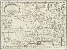
French edition Carey & Lea's map, the first map of Michigan Territory. Virtually no settlements in the interior and the upper peninsula, with most of the towns concentrated on the southeast border. The remainder is Indian Territory, w/notes on Portages. Includes Indian Settlements, and a rew early counties, including Monroe, Oakland, DeWayne and Macomb. Early roads shown and some settlements on Lake St. Claire and Lake Erie, along with Ft Brown and Camp Smith south of Green Bay. A few pinholes, else a very nice example of this increasingly hard to find early map of Michigan. Surrounded by text describing Michigan Territory. A nice example, with a bit of waterstaining in the upper margin and minor soiling in the map. Ordinarily a $750.00 map.
Jean Alexandre Buchon (1791-1849) was a French scholar and historian. Born as the French Revolution raged, Buchon was dedicated to recovering France’s history in order to help the country heal and grow. He gathered French stories and published them as part of Collection des chroniques nationales franciases ecrites en langue vulgaire, du XIe au XVIe siècle (4 vols, 1824-1829). He also compiled and published an exploration collection and several histories, particularly about medieval France.
For geography, his most important contribution was publication of the French edition of Carey & Lea’s American Atlas in 1825. Each page of the atlas includes highly detailed text about the state or territory depicted, as well as a map of the area. The French edition is generally considered in high regard as compared to other editions, as it has quality paper and superior engraving.


![[ Ohio - Seven Ranges ] Plat of the Seven Ranges of Townships being Part of the Territory of the United States N.W. of the River Ohio which by a late act of Congress are directed to be sold . . . 1785](https://storage.googleapis.com/raremaps/img/small/82394.jpg)
