|
||

|

|
|

|
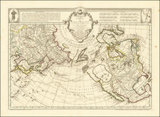
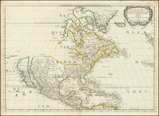
Rare Swedish map of North America, published by Akerland in Stockholm in 1827.
The map is dominated by a massive Fria Indianer Lander (Free Indian Lands) in the Utah-Nevada area, with a fascinating depiction of the Trans-Mississippi West, including Lake Timpanogos and Lake Tegujo (sic). Further south in the Arizona/New Mexico area, the ruins of an ancient Indian town are noted.
The entire western part of the map is filled with Indian names. In Texas, the region south of the Red River near the modern location of Dallas is referred to as Fruktbar Slattmark (Fruitful Plains).
A number of early western trading forts are shown, including:
- Fort Fabry, a trading house constructed by Fabry de Bruyere in 1741 on the Arkansas River.
- Fort Clark (also called Fort Sibley and Fort Osage), a trading house on the Missouri River established by the US Government in 1808 for trading with the Osage Nation.
The place names in Alaska are primarily Russian names, with a generally very unusual coastline.
Nya Albion (New Albion) and Nya California (New California) are shown, with N. Cornwall, N. Hanover and N. Georgian along the coast of Alaska, Canada and Washington. Indian tribes are shown, along with significant post-Lewis & Clark details in the northwest.
A number of Hudson Bay Company Factory Houses are shown in western Canada and at least one Northwest Company Trading house on the south side of Lake Superior. In Michigan, Fort Detroit and Fort St. Clair are shown, with Fort Meigs in Ohio, and Ft. Clark, Ft. Edward, Ft. St. Louis and Ft. Massac in Illinois.
The Columbia River mistakenly shown in the general vicinity of the Upper Fraser River.
A fine example of this rare map.
![The Theatre of War in North America, with the Roads, and Tables, of the Superficial Contents, Distances, &c.a By and American [with] A Compendious Account of the British Colonies in North-America.](https://storage.googleapis.com/raremaps/img/small/81762.jpg)