|
||

|

|
|

|
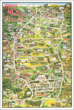
Scarce pictorial map of New Zealand, published by the New Zealand Government Tourist Department and designed by the Charles Haines Advertising Agency of Wellington.
Inset shows railways within New Zealand and sea and air routes from overseas.
Includes photographs and tourist information on verso. As noted on the La Jolla Map & Atlas Museum Website:
[thee map was] issued by the New Zealand Government Tourist Bureau and printed by E.V. Paul after designs by Charles Haines, the first advertising agency in New Zealand, founded by Haines in 1891. While the promotional material on the verso of the map is designed to encourage tourism, and offers free assistance to travelers, the map on the front is more whimsical in nature:
“… there is no need to offer apologies for the appearance of the ‘Fun Map of new Zealand’, which, while making humorous reference to many historic and notable incidents in the Dominion’s history, does so without malice and a spirit of genuine light-heartedness. From the delightful representation of the ‘Three Kings’ in the far north, all looking slightly ‘blue’ as though feeling ‘just a little bit out of it’, to the busy oyster-scoopers of Foveaux Strait, there is one big smile for owners of the ‘Fun Map’”.
![Isles de Salomon [Early depiction of New Zealand!]](https://storage.googleapis.com/raremaps/img/small/101683.jpg)