|
||

|

|
|

|
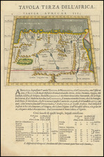
Rare image of the Fort/Citadel of Goletta, shortly after construction and prior to the Turkish Siege of Tunis in 1574.
According Vilar, and Poinssot-Lantier (see Akacha-Garulli, p. 87), this engraving represents the initial project conceived by Jacopo Paleari Fratino in 1566, with the addition of a bastion in fine lines. The project, which was going to improve and to expand the fortification built in 1535 by Antonio Ferramolino and modified several times up to the early 1560s, was discussed and approved by a commission composed by the viceroy of Sicily, Don Garcia of Toledo, the royal engineers of Naples Giovanni Tommaso Sacla, Giacobbe Santieri (or Giacomo Lanteri) and Gabrio Serbelloni who, in 1573, would go on to design the fort of Tunis.
Philip II sent 50,000 ducats with instructions to finish the works by winter 1566-67, but the funds and construction would last until July 1573. To the four-pointed star form, the Fratino added a bastion with flanks withdrawn from the side towards Carthage, the must vulnerable side. At the corners he created four half-bastion, inserting between these three sheltered curtains. The whole was surrounded by a moat.
Later, the bastion would add a barracks. This change dates back to 1569, and may have been designed by the governor Alfonso Pimentel or his brother Alonso. Marcel Destombes attributed the typography to Antonio Lafreri.
Siege of Tunis
In the autumn of 1573, thanks to the undertaking of King John of of Austria, Spain was able to reconquer Tunis, from Ottoman control.
In the summer of 1574, the Ottoman Empire rebuilt its fleet and organized a powerful expedition under the command of Ululg’Ali. In Tunis, during the brief Spanish rule, a sort of protectorate had been established for which, alongside the prince Hafsida, to whom the government of the Moors was left, was appointed the Milanese Gabrio Servelloni. During this government, the construction of a citadel was commissioned, to be located between the bay and the city of Tunis, contrary to the suggestions of Philip II, who suggested the dismantling of all fortresses.
The engraving depicts the Bay of Tunis during the siege by the Turks in July 1574 at the Goletta citadel. The Turkish expedition, supported by forces Maghreb Muslims, would permanently eliminate the Spanish presence in Tunisia.
Antonio Lafreri (1512-1577) (also known as Antoine Lafréry and Antoine du Pérac Lafréry) was a French mapmaker, engraver, and publisher who worked in Italy. Lafreri was born in Franche-Comté and moved to Rome around 1540. Lafreri sold sheet maps but he also bound maps into books for his clients based on their interests and needs. These are the famous Lafreri atlases, important pre-cursors to the modern atlas. He also published well known works such as the Speculum Romanae Magnificentiae (ca. 1575), a collection of engraved views and images of Rome. Lafreri was well-connected to the cartographic networks of the time, collaborating with Giacomo Gastaldi, Battista Agnese, Antonio Salamanca, Donato Bertelli, Paolo Forlani, and others.
![Goletta, et Novo forte avanti Tunesi, co[n] l’Assedio p[er] terra, et p[er] Mare d[e] Turchi et Mori, el luglio, et agosto .74. Co[n] li gra[n] sforci de Sina[n] bassa[n], et d[e] Ucchiali capitt.o de l’Armata, et le mirabil prove fatte in Goletta da Do[n] Pietro Carreea et dal S.Gabrio Serbellone nel nuovo forte, con mortalita incredibile d[e] Turchi, et Mori.](https://storage.googleapis.com/raremaps/img/small/61733sb.jpg)