|
||

|

|
|

|
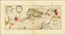
The Rampant Lion -- Symbol of Holland's New Independence, Patriotism, Spirit of Defiance and Optimism
Perhaps the single most famous of all cartographic curiosities are the maps showing the Low Countries depicted in the form of a lion.
As noted by Ashley Baynton Williams (Mapforum #12):
The allegorical lion was first introduced by Michael Eitzinger (Aitzinger or van Aitzing) in 1583. The idea may have suggested to him by the presence of a lion in the arms of most of the Seventeen Provinces. Whatever his inspiration, the genre proved very popular, and a number of later publishers produced their own versions, some even introducing their own sub-type.
One such group was the 'Leo Hollandicus', where the [Province of Holland is] depicted as a lion. Claes Jansz. Visscher was the first to publish such a map, as shown here.
Since Aitzinger had published his prototype, the political situation had altered considerably. The [Dutch] Provinces has risen in revolt against the Spanish, who succeeded in subduing the southern provinces, but not the seven northern provinces. The Revolt was suspended during the Twelve Years Truce (1609-1621), before resuming, and continuing to 1648, when the Dutch Republic established its independence.
Visscher seems to have first published the map before 1625, the year in which the dedicatee Prince Maurice died. A second example was published dated 1633, while the third state was published in 1648, when the Spanish confirmed Dutch independence.
The map captures the spirit of the young country: its civic pride, with the fine vignette views of the principal cities, the entrepreneurial spirit, with the depictions of the iceboat and land yacht, while the lion, standing on its hindlegs, with the large sword bearing the motto 'PATRIAE DEFENSIO'. The 'Leo Hollandicus', therefore, reflects the new independence, patriotism, spirit of defiance and optimism of the Dutch Republic, and this engraving apparently proved a popular encapsulation of the popular feeling of the day.
The vignettes of costumed figures (note Simon Stevin's famous land-yachts in the upper right-hand panel) and views of the principal towns and cities of the province are adapted from Willem Janszoon Blaeu's map of Holland of 1608.
![(Rare Czech Edition!) [Asia Secunda Pars Terrae in Forma Pegasi] [Asia in the Form of Pegasus]](https://storage.googleapis.com/raremaps/img/small/95830.jpg)
![(Nuremberg Chronicle) [Geneology of the Tribes of Israel]](https://storage.googleapis.com/raremaps/img/small/98708.jpg)