|
||

|

|
|

|
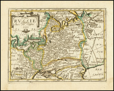
An Exceptional Old Color Example
Fine old color example of Joseph Nicolas De L'Isle's map of the western Caspian Sea region, published by the Akademiia nuk SSR in St. Petersburg, Russia.
The map shows the area between the Volga estuary in the north and the mouth of the Kura river in the south, including Dagestan and Azerbaijan Includes and elaborate cartouche on lower left corner, with 4 figures representing different peoples of the Caucasus.
The map appeared in the first atlas of Russia, published by the Academy of Sciences in St. Petersburg, expanding on the cartographic work done previously by Ivan K. Kirilov. Postnikov notes:
It brings together all the geographical discoveries of the early 18th century to give a fuller picture of the entire Empire than shown in the so-called Kirilov atlas. The maps were mostly based on instrumental surveys, geographical descriptions and maps compiled by the Petrine geologists and their successors."
A fine example of this rare early regional map.
![[ St. Peterburg ] Plan de St. Petersbourg et de ses environs relatif au Memoire, concernant les moyens de mettre cette ville a l'agbri des inondations et d'etablir deux grands ports, dessine d'apres des cartes exactes, par le chevalier de Wiebeking, conseiller prive de S.M. le Roy de Baviere, etc. (With separately published Legende du Plan De St.-Petersbourg . . . )](https://storage.googleapis.com/raremaps/img/small/64539.jpg)
![[Armenia] Armenia Vetus In Quattuor Partes distincta ad Tepora Iustiniana Imp. . . . 1653](https://storage.googleapis.com/raremaps/img/small/91739.jpg)
![[ Black Sea ] The Euxine or Black Sea From The Russian Survey of 1826](https://storage.googleapis.com/raremaps/img/small/99954.jpg)