![Historiarum Indicarum Libri XVI [with:] Indiarum Orientalium Occidentaliumque Descriptio. Pet. Maffei Historiae Harum Verissimae, Dedicata. By Peter Maffei](https://storage.googleapis.com/raremaps/img/small/102793.jpg)


|
||

|

|
|

|
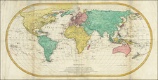
Rare, Early Italian Map of the World
Fine world map with decorative strapwork detailing. The map is based on Ortelius’ 1570 world map.
This map appears in Giovanni Maffei's account of the Portuguese accomplishments made throughout India and the Far East. First published in Florence in 1588, several subsequent editions of Maffei’s account were published in Antwerp, Bergamo, and Venice. However, only those published in Cologne in 1589 and 1593 contain this world map.
The source map for this work was Abraham Ortelius’ world map first published in his famed Theatrum Orbis Terrarum in 1570, the first modern atlas.
The map is bordered by intricate strapwork designs at each corner. The title cartouche is another fine example of strapwork illustration. The Ortelius world map is also characterized by bordering strapwork, but the style of the decorative elements of this map is distinct and clearly completed by an accomplished engraver.
Sailing vessels and sea monsters adorn the map, including a particularly large whale with double blowholes located in the southern Indian Ocean.
There are a number of notable geographic details contained in this map, both real and imagined. The large southern continent, referred to here as Terra Australis Nondum Cognita, is separated from South America by the Strait of Magellan and includes Terra del Fuego and several place names gleaned from Marco Polo’s travels. New Guinea is shown as an island, although the accompanying annotation recounts a lack of clarity on its status as an island or as part of continental Terra Australis.
The misprojection, or bulge, of South America’s western coast popularized by Ortelius can be clearly seen as well. North America includes fabled places such as Anian, Quivira, and Cevola, as well as an early conception of the St. Lawrence river and a number of guesswork mountain ranges. East Asia reflects further information from Marco Polo’s Travels.
At the time this map was created, much of the world was still uncontacted by Europeans. The Western Hemisphere, Far East Asia, and much of the Pacific were all relatively unknown, and the Australian continent had yet to be encountered. Cartography largely relied on travel accounts that could not be verified, so while many of these areas are conjectural, the relative accuracy of most of this map is impressive.
The hope of a Northwest Passage and cities of gold
The title cartouche obscures most of the northern regions of this map, but at the edges of the cartouche hints of the fabled Northwest Passage can be seen. The Northwest Passage, believed to connect the Atlantic to the Pacific through North America, was long sought after by Europeans as an alternative route to the Far East. The first recorded exploration attempt was undertaken by John Cabot in 1497, but the general idea of a Northwest Passage originated in antiquity and was reprised by the fifteenth century revival of Ptolemaic maps. Speculations about the passage appeared on maps until the mid-eighteenth century, and numerous explorations were undertaken in search of a navigable sailing route.
On this map, a branch of the St. Lawrence river runs off the northern boundary of the map frame, and at top left a passage can be seen entering North America north of the Anian region. The name Anian derives from Ania, a Chinese province on a large gulf mentioned in The Travels of Marco Polo. The gulf Polo described was actually the Gulf of Tonkin, but due to misreading the province’s description was transposed from Vietnam to areas much farther north, typically in Asia, but located on this map’s North America. The Anian region is associated with the Straits of Anian, a mythical passage separating China and North America that became shorthand for the existence of the Northwest Passage.
Also in North Americas are Quivira and Cevola. These refer to two of the fabled Seven Cities of Gold sought by the Spanish explorer Francisco Vasquez de Coronado in 1541. Although Coronado did not prove their existence, names associated with the Seven Cities of Gold remained popular toponyms on renderings of North America.
The southern continent
Maffei’s map also contains the sprawling southern continent, Terra Australis Nondum Cognita, also commonly referred to as variants of Magellanica, named after Ferdinand Magellan, and Terra Australis Incognita, in the tradition of Ptolemaic maps. In antiquity, Greco-Roman scholars and cosmographers such as Ptolemy posited that the Indian Ocean was enclosed by land, and that the continents of the globe should be balanced, in that the amount of land found in the Northern Hemisphere should exist in the Southern Hemisphere.
Ferdinand Magellan’s 1520 discovery of Tierra del Fuego was thought to support claims of a southern continent, and many prominent mapmakers, including Gerardus Mercator, strongly believed in the continent’s existence. This belief was eventually disproven by James Cook’s first (1768) and second (1772) voyages through the southern Pacific.
Maffei’s map, besides containing Magellan’s discoveries, also shows Psitacorum regio (“Country of Parrots”) and comments on the largeness of the birds recounted in Portuguese sailor’s logs. Psitacorum regio notably appeared on Gerard Mercator’s 1541 globe and his 1569 world map. This map also locates the promontory of Terre Australis.
The place names Beach, Maletur, and Lucach can be found at the tip of the southern continent in Southeast Asia. The location of these toponyms on the southern continent and of Java Minor’s (provinces of Sumatra) southern placement originated from a series of misunderstandings and a faulty printing of Marco Polo’s Travels. Mare Lantchidol is similarly an inaccurate transcription of the Malay-Javanese term ‘Laut Kidul’ (South Sea), also stemming from Marco Polo’s accounts.
Sources and rarity
The source map for Maffei’s work, Ortelius’ world map of 1570, was published in the first edition of Theatrum Orbis Terrarum and continued to feature in following editions. The Theatrum enjoyed unmatched popular success and was published in 31 editions between 1570 and 1612. The widespread success of Ortelius’ work made the world map a popular source map for contemporary engravers and publishers. At the time Maffei’s map was engraved, this depiction of the world would have been welcome and familiar to a large audience.
Giovanni Maffei’s world map, complete with finely engraved strapwork details, is a rare find. This is only the second time we have featured the map.
![(Early Photographic Facsimile of the Mappamundi of Tunuslu Hajji Ahmed) Kemãl ile Naks Olinmis Cümle-I Cihãn Nemunesi [Fully Illustrated Exposition of the World in Its Entirety]](https://storage.googleapis.com/raremaps/img/small/66562.jpg)