|
||

|

|
|

|
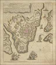
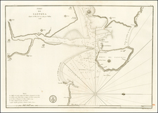
The Anglo-Dutch Capture of Gibraltar in August 1704
Rare early sea chart of the Bay and Town of Gibraltar, illustrating a military and naval engagement at Gibraltar in August 1704, which resulted in the taking of Gibraltar by a combined British and Dutch Naval invasion in support of the Grand Alliance, during the War of Spanish Sucession.
Oriented with east at the top, the image shows a pitched battle between the Spanish Garrison at Gibraltar defending against the massive Dutch and British invading forces, which lasted for 4 days, before the Spanish surrender.
The naval engagement shows the Dutch fleet, under the command of Philips van Almonde, Gerard Callenburgh and Jacob van Wassenaer Obdam, and the English Fleet, under the command of George Rooke, Edward Russell and Clowdisely Shovell.
Grand Alliance was ultimately unsuccessful in its support of Charles III as the next King of Spain, the battle would result in England's retention of Gibraltar as its foothold at the entrance to the Mediterranean.
The Capture of Gibraltar
Since the beginning of the war, the Anglo-Dutch Alliance had eyed the capture of Gibraltar as a means of strengthening its position against the French fleet in the western Mediterranean Sea. An attempt to take Cádiz failed September 1702, but after a successful raid on Vigo in October 1702, the combined Alliance forces became the dominant naval power in the region.
The new naval power was a factor in King Peter II of Portugal's decision to end Portugal's alliance with France and Spain, shifting allegiance to the Anglo-Dutch forces in 1703. With access to Lisbon, the Alliance fleets could effectively campaign in the Mediterranean and operate in support of the Austrian Habsburg candidate to the Spanish throne, the Archduke Charles, known to his supporters as Charles III of Spain.
In May 1704 the Prince George of Hesse-Darmstadt and Admiral George Rooke, commander of the main Grand Alliance fleet, failed to take Barcelona in the name of 'Charles III'. The Alliance commanders resolved to capture Gibraltar, a small town on the southern Spanish coast. Following a heavy bombardment the town was invaded by English and Dutch marines and sailors. The governor, Diego de Salinas, agreed to surrender Gibraltar and its small garrison on August 4, 1704. Three days later Prince George, entered the town with Austrian and Spanish Habsburg troops in the name of Charles III of Spain.
The Grand Alliance failed in its objective of replacing Philip V with Charles III as King of Spain, but in the peace negotiations Gibraltar was ceded to Britain.
A month after its capture, British Secretary of State Sir Charles Hedges described it as 'of great use to us for securing our trade and interrupting the enemy's'. The position significantly deterred the Moorish pirates of the Barbary Coast from attacking English merchant shipping, and resulted in their allying themselves with Queen Anne.
The English embarked on a program to strenghen its position and John Methuen recommended an English garrison. This was supplied by the marines that had helped take the place, and by several companies of regular troops. Gibraltar was, therefore, held by English troops and at English cost, but in the name of 'Charles III'.
Following an attempt by the French Grand Fleet to retake Gibraltar, in 1711, the British and French Governments started secret negotiations to end the war leading to the cession of Gibraltar to the British by the Treaty of Utrecht in 1713.
The Van Keulens were a family of chartmakers and publishers. The firm, In de Gekroonde Lootsman (In the Crowned Pilot), was founded in 1678 by Johannes van Keulen (1654-1715). Van Keulen originally registered his business as a vendor of books and instruments (specifically cross-staffs). In 1680, however, he gained a privilege from the States of Holland and West Friesland for the publication of pilot guides and sea atlases.
In that year, van Keulen released his Zee-Atlas (Sea Atlas), which secured him a name in the competitive maritime publishing market. In 1681, he published the first volume of Nieuwe Lichtende Zee-Fakkel (New Shining Sea Torch). This would be the first of an eventual five volumes originally published between 1680 and 1684. A sixth volume was added in 1753. The Zee-Fakel won van Keulen lasting fame. The atlas had charts compiled by Claes Jansz Vooght and artwork from Jan Luyken. It proved immensely popular and was reprinted until 1783. There were translations in French, English, Spanish, and Italian.
The late-seventeenth century was an auspicious time to enter the maritime chart business. Previous industry leaders had either closed shop, died, or retired, leaving space for a new competitor. Van Keulen proceeded to buy up the stock and privileges of several maritime publishing firms; the most notable was the stock of Hendrik Doncker, acquired in 1693.
Johannes’ son, Gerard (1678-1726) took over the business upon his father’s death. Gerard was a skilled engraver and mathematician. His talents were noticed, as in 1706 he was named as Hydrographer to the Dutch East India Company (VOC).
In turn, Gerard’s son Johannes II (1704-1770) came to run the shop. He was also tied to the VOC, and his role as their chartmaker allowed his charts to be considered as quasi-official government documents. It is with access to formerly clandestine VOC geographic knowledge that Johannes the Younger was able to add a sixth volume to the Zee-Fakkel, which covered the East Indies. Johannes also continued to sell instruments, including the recently-invented Hadley’s Quadrant from 1744.
When Johannes II died in 1770, his widow ran the business in his stead, aided by her two sons, Cornelis Buys (1736-1778) and Gerard Hulst (1733-1801). Now a century old, the family business had extended to include an anchor factory. After Cornelis died in 1778, Gerard took on the management of the firm alone. He oversaw the introduction of sextants to their inventory and published the Dutch Nautical Almanac beginning in 1788. Annual editions appeared until 1885. Gerard also served as an original member of the Dutch Commission for Longitude at Sea from 1787.
Gerard’s widow ran the business for nine years after his death, when their son, Johannes Hulst, started to lead the firm in 1810. After his death in 1844, the firm passed out of family hands and into the control of Jacob Swert, a skilled cartographer who had worked for the business for two decades. He passed the work to his son, another Jacob, in 1866. By the mid-nineteenth century, the conversion from sail to steam had diminished the size of the market for charts. Fewer sailors needed fewer maps, charts, and instruments. In 1885, after 207 years in business, In de Gekroonde Lootsman closed its doors and auctioned its stock.
![[ Spain & Portugal ] Hispania Nova Tabula](https://storage.googleapis.com/raremaps/img/small/103676.jpg)