


|
||

|

|
|

|
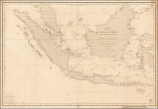
A Diplomatic Exchange of Cartographic Information in the Far East
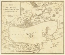
Rare map of the Philippines, based upon the work of Alessandro Malaspina, perhaps earliest example of Malaspina's mapping of Philippines to appear in print.
The map is drawn from information derived by Chrétien-Louis-Joseph de Guignes from a member of the Malaspina expedition, one of the most important voyages of exploration of the 18th century (see below). In 1792, Malaspina's expedition sailed from Mexico across the Pacific Ocean. They stopped briefly at Guam before arriving at the Philippines, where they spent several months, mostly at Manila. After the Philippines, the Malaspina expedition set sail for New Zealand, remaining in Australasia and the South Pacific for the remainder of the expedition.
The map is drawn from information which was apparently given by Malaspina or a member of his expedition to Chrétien-Louis-Joseph de Guignes (1759–1845). Guignes was a French merchant-trader, ambassador and scholar, born in Paris, the son of French academician and sinologue, Joseph de Guignes. In 1784, Guignes traveled to China as Resident of France in China and consul at Canton, where he remained until 1801, making periodic trips to Manila during his 17 year stay, where he apparently encountered Malaspina.
From 1794-95, de Guignes served as an interpreter while traveling through eastern China with Isaac Titsingh, the Dutch ambassador to the court of the Qianlong Emperor of China. Heading to Beijing to celebrate the sixtieth anniversary of the Qianlong Emperor's reign, Titsingh and his colleagues conformed to the demands of the Chinese court etiquette and succeeded in developing good relations with China. De Guignes and the members of the Titsingh mission were the last European diplomats to appear before the Imperial court until after the Opium Wars of the next century.
During his journey, de Guignes made observations on Chinese history, society and culture, geography, economics, and manufacturing. Upon returning to France in 1801, de Guignes published an account of his 17 years of travels through China, the Philippines, and Mauritius, which included two maps of Philippine interest, engraved by D'Houdan, which appeared in the atlas to accompany his travel account, Voyages à Peking, Manille et L'Ile de France faits dans l'Intervalle des Années 1784 à1801, published in Paris in 1801.
- Carte des Iles Philippines. The map shows Guignes' route through the central Philippines and notes several banks to the west of Manilla. Marked sheet No. 96 at top right.
- Baie de Manille par M. de Malespina. The map shows Manilla Bay along with the city of Manilla. A number of soundings, anchorages, and islands are shown in the waters with a few place names identified along the coastline. Marked sheet No. 97 at top right.
Based upon the chronology above, this would seem to be one of, if not the earliest printed version of Malaspina's cartographic accounts of the Philippines.
Malaspina Expedition
The Malaspina Expedition (1789–1794) was a five-year maritime scientific exploration commanded by Alessandro Malaspina and José de Bustamante y Guerra. Although the expedition receives its name from Malaspina, he always insisted on giving Bustamante an equal share of command. Bustamante however acknowledged Malaspina as the "head of the expedition" since the beginning
The expedition was funded by the Spanish government and originally pursued strictly scientific goals, in the same fashion as the voyages of James Cook and Jean-François de Galaup, comte de La Pérouse. Some of the leading scientists at the time collected an impressive amount of scientific data that even surpassed what was collected during Cook's expedition.
Unfortunately, Malaspina's political judgment lead him to take part of a failed conspiracy to overthrow Spain's Prime Minister Godoy, and he was arrested on November 23 on charges of plotting against the state. Charles IV decreed that Malaspina be stripped of rank and imprisoned in the isolated fortress of San Antón in La Coruña, Galicia (Spain), where he remained from 1796 to 1802, after which time he was exiled.
It was estimated that publication of the reports of the expedition would fill seven large volumes, at a cost of two million reales (250 000 Spanish dollars or about £12 500). José de Bustamante attempted to have the journal and reports of the expedition published, but the cost was beyond the resources of the Spanish treasury, particularly its naval budget, during the years of strife that followed Malaspina’s arrest. It took two hundred years for the vast majority of the records of the expedition to be published. Over time, the material was scattered among several Spanish archives and some material was lost.
Alexander von Humboldt, an admirer of Malaspina, wrote, "this able navigator is more famous for his misfortunes than for his discoveries."
The notes made by the expedition’s botanist, Luis Neé, while he was at Port Jackson in 1793 were published in 1800. Dionisio Alcalá Galiano’s journal of his survey of the straits between Vancouver Island and the mainland, carried out as part of the Malaspina expedition, was published in 1802 with all mention of Malaspina’s name excised. In 1809, José Espinosa y Tello published the astronomical and geodesic observations made during the expedition in a two-volume work that also contained an abbreviated narrative of the voyage. This narrative was translated into Russian and published by Admiral Adam von Krusenstern St. Petersburg in 1815.
The journal of Malaspina’s voyage was first published in Russian translation by Krusenstern in successive issues of the official journal of the Russian Admiralty between 1824 and 1827 (a copy of the manuscript had been obtained by the Russian ambassador in Madrid in 1806). The journal of Francisco Xavier de Viana, second-in-command of the Atrevida was published in Montevideo in 1849. Bustamante’s journal was published in 1868 in the official journal of the Directorate of Hydrography. An abbreviated account of the Malaspina expedition, consisting mostly of his journal, "Diario de Viaje", was published in Madrid in 1885 by Pedro de Novo y Colson. Malaspina’s journal was published in another edition in Madrid in 1984.
The definitive version of the expedition was finally published in Spain by the Museo Naval and Ministerio de Defensa in nine volumes from 1987 to 1999. The second volume of this series, Malaspina's journal, was published in an annotated English translation by the Hakluyt Society in association with the Museo Naval between 2001 and 2005.
The drawings and paintings done by members of the expedition were described by Carmen Sotos Serrano in 1982. The 4,000-odd manuscripts relating to the expedition were catalogued by Maria Dolores Higueras Rodriguez between 1989 and 1994.
Rarity
This is the first time we have ever seen this map offered separately for sale.
![[Philippine Islands] Carte du Canal des Isles Philippines Par leque passe le Galion de Manille. Et les Iles voisines de ce canal.](https://storage.googleapis.com/raremaps/img/small/47117.jpg)