


|
||

|

|
|

|
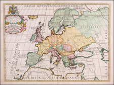
The Rare English Copy of Waghenaer's General Sea Chart of Europe -- The Earliest Sea Chart Engraved in England -- Engraved by Jodocus Hondius
Important early sea chart of Europe, engraved by Jodocus Hondius for the The Mariner's Mirrour, an English translation of Waghenaer's Spiegel der Zeevaerdt, which was published in London in 1588.
First produced in Dutch by the master sea pilot, Lucas Janszoon Waghenaer, and translated into English in 1588, the year of the Spanish Armada, by the politician Anthony Ashley, with all the charts re-engraved by various engravers, 17 of which are signed, including 10 by Theodore de Bry, 3 by Jodocus Hondius, 3 by Augustine Ryther, and 1 by Jan Rutlinger, each of whom was then living and working in London.
From the introduction to the 'Mirrour,' it seems that the Latin edition was not considered to meet the needs of the English navigators, for Anthony Ashley records in his preface that in 1587 at the "commandment and charge" of Sir Christopher Hatton, he undertook the task of translating the 'Spieghel' into English.
The chart provides a fine depiction of the sea coasts of Europe, the British Isles, Iceland, and the western Mediterranean, including the mythical Island of Brazil. Richly embellished with compass roses, a sea monster, sailing ships, coats of arms and rhumb lines.
The English map is a copy of the first state of Waghenaer's chart of Europe, retaining the circular depiction of Iceland. It can be readily distinguished from the original by the large British coat of arms below the British Isles and the English scale of miles at the left side of the map.
Waghenaer's Spiegel was the first engraved sea atlas, making this sea chart of Europe and the Western Atlantic the earliest printed sea chart of the region. Because this chart was significantly larger than the others in the atlas, it rarely appears on the market in good condition.
Waghenaer (c. 1533-1606) was a Dutch marine cartographer and navigator. He grew up in the important port of Enkuizen. From 1550-1579 he served at sea, increasing his practical knowledge of sailing and charting. His first publication was the famous Spiegel der Zeevaerdt, or Mariner's Mirror, which appeared in 1584. The work was reprinted and translated into several European languages. The combination of detailed charts accompanied by sailing directions set a precedent and model for subsequent sea atlases, which came to be called waggoners. Waghenaer published two other works, Thresoor der Zeevaert ( Treasure of navigation) in 1592 and the Enchuyser zeecaertboeck (Enkhuizen sea-chart-book) in 1598. He died in 1606.
Originally engraved by Joannes Doetecum, the English edition was engraved by Jodocus Hondius, one of the earliest maps engraved by Hondius.
The island of Brazil, or Hy Brasil, shown here typically as a circular island with a river bisecting it, is part of Irish folklore. It is said to appear from a constant shroud of mist for one day every seven years. However, as Barbara Freitag has shown, the island was only Gaelicized in the mid-nineteenth century. It was originally the product of late medieval and early modern Mediterranean mapping practices that named and located Brasil Island off the west coast of Ireland. It first appeared on portolan charts as early at 1325 and continued to wander the eastern Atlantic in charts by Ortelius and Mercator, among others. In the 1480s, Bristol merchants sent two expeditions to search for the place, while sightings continued into the mid-nineteenth century. By then, however, geographers had started to identify the island as Brasil Rock and hypothesized that it was part of a shoal or rocky outcrop that had appeared as something more substantial when viewed across foggy waters. The Waghenaer chart, therefore, is as important as it is a practical sailing aid, yet it is also a chronicle of geographic chimeras.
A remarkable rarity--this is the first example of the English sea chart of Europe which we have ever seen on the market.
Koeman, C. "Lucas Janszoon Waghenaer: A Sixteenth Century Marine Cartographer." The Geographical Journal. Vol. 131, No. 2 (Jun., 1965), pp. 202-212.
![[Hand-Drawn Map Showing the Extent of the Ottoman Empire]](https://storage.googleapis.com/raremaps/img/small/99654.jpg)
![[Signed Political Satire Artwork] Vietnam ... Vietnam ... Vietnam ...](https://storage.googleapis.com/raremaps/img/small/68726.jpg)
![[Eclipse of May 12, 1706] Europa Christiani Orbis Domina in Sua Imperia Regna . . .](https://storage.googleapis.com/raremaps/img/small/91457.jpg)