|
||

|

|
|

|
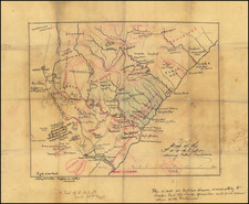
"We had posession of all the material that existed, and we compiled it as best as we could." -- Boer War Mapping of Bloemfontein
Detailed map of the Bloemfontein region of Transvaal and Orange Free State, one of nine sheets created to display the region by the Ordnance Survey in 1899.
The map shows rivers, creeks, towns, villiages, homesteads, police stations, hotels, roads, tracks, native settlements and railways. Relief shown by form lines, hachures and barometer heights. The map is part of a series of maps covering all of Orange Free State and most of Transvaal, produced during Boer War.
The set and individual sheets are very rare on the market. The Bodleian holds 6 sheets; Kimberley, Boshof, Hopetown, Bloemfontein, Philipstown and Bethulie.
British Ordnance Survey Mapping During The Boer War
The Anglo War was contested between the Orange Free State and the South African Republic against the British Empire, between October 1899 and May 1902.
When the war started, South Africa was largely unmapped in meaningful detail. Prior to the war, the British War Office had sent officers to Natal and the Cape Colony to do reconnaissance mapping. During the war, 2 survey details and 3 mapping details were sent to South Africa to
The military surveyors worked closely with the existing Offices of the Surveyors-General to produce two types of map, one from existing sources called a compilation map, and the one a conventional topographic map based on a topographic survey.
The local survey departments acquired valuable expertise in surveying and mapping during these exercises and the maps thus produced would be the only maps of large parts of the country for many years. With the cessation of hostilities, Britain realised that if it wanted to sustain its imperial influence in Southern Africa, it would have to make provision for the topographic mapping of the colonies. As a result, survey sections were despatched to South Africa to undertake accurate topographic mapping in the Orange River Colony, the southern Transvaal and the north-western Cape Colony.
As noted by Liebenberg:
Prior to the war the best Britain could do was to collect as much information as possible and to make it available in mapped form. Officers were sent along the principal routes in the Transvaal and Orange Free State, and their work was reproduced in the form of notes and route sketches. Sketches were made of all the bridges and their surroundings; where it was proposed to place garrisons; and of the points selected for advanced depots. In 1903 the Report of the
Royal Commission on the War noted: ìThe [Intelligence] Department was in possession, during the period 1896-99, of all map material of all parts of South Africa affected by the war, which was known to exist, either in the shape of published maps and sketches, unpublished surveys and plans, and MS work. Every attention was given to the compilation of this information into map form . . .The first map to be produced as a result of these endeavours was Intelligence Division War Office No. 1367, Transvaal and the Orange Free State, on a scale of 1 : 250 000 (1 inch per 3.94 miles). This series consisted of 28 black and white sheets and was compiled from existing maps, the information contained in reports and reconnaissance sketches of officers who had been sent to South Africa six months before the war, plans supplied by local surveyors, and the oral accounts of transport riders and commercial travellers. The maps were naturally not very accurate, and it is questionable whether they were ever used for strategic purposes. They were, however, the only maps available when the British Army started its advance on Pretoria from Cape Town in January 1900 and they did show the drifts over the rivers, the roads, some important placenames and the most important watering places. The relief features were merely sketched in. Charles Close, looking back on that period, called them ìrough, inaccurate and clumsy: and Major SCN Grant, who supervised their production at the War Office and became Director-General of the Ordnance Survey in 1908, referred to them as follows after the war: " . . . if you have not money to make a survey, what are you to do? It is either that or to have no maps at all . . . We had posession of all the material that existed, and we compiled it as best as we could."
![[With Flags Added] The](https://storage.googleapis.com/raremaps/img/small/79510.jpg)
![Egypt and Barca [with] Abissina and Nubia [with] Congo. Angola. Cafres. Monoemugi. Monomotapa. Zanguebar & Madagascar](https://storage.googleapis.com/raremaps/img/small/78890.jpg)