|
||

|

|
|

|
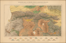
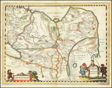
A rare, large-format map depicting the great ancient Armenian Kingdom of Urartu which flourished between the 9th and 6th Centuries BCE, featuring the locations of now lost cities and places of worship, as well battle sites and areas of commerce, predicated upon a generation of ground-breaking research by Professor Suren Yeremian, the most esteemed Armenian historical geographer of the 20th Century.
This large and rare separately issued Armenian language map showcases the historical Kingdom of Urartu, a great Armenian civilization that occupied the Biblical ‘Mountains of Ararat’, extending from Eastern Anatolia, through the south Caucuses to north-western Persia. The Urartian state thrived between 860 and 590 BCE and this time is considered to be a golden period in the ancient history of the Armenian people, who over a period of 4,000 years have created a series of different states in various places in the greater region.
To be clear, this is not a ‘school map’ copied from other sources, but an important academic work predicated upon the ground-breaking archival research of Professor Suren Yeremian, the foremost historical geographer of Armenia of the 20th Century.
The map shows that the Kingdom of Urartu encompassed a large territory; while centered on Lake Van, it ranged from Central Anatolia, all the way over to north-western Persia. The core part of the kingdom is shaded in dark pink, while areas temporarily held by the Urartian regime are shaded light pink. The various ancient districts are named, as are the precise locations of dozens of major cities and towns, most of which had by modern times long vanished. Roads and caravan routes are delineated, while much economic information, being the locations mines, quarries and wine regions (Armenia was one of the first places in the world to produce wine!), as well as areas for the grazing cattle, camels, and sheep. The map also marks the sites of key military battles, with dates. Importantly, much of this information appears for the first time in Yeremian’s work.
The present map is rare – despite our best efforts, we could not trace the location of another example.
Suren Yeremian Maps the Kingdom of Urartu
While the approximate locations of the boundaries and some of the key centers of the Kingdom of Urartu were commonly known over the succeeding 2,500 years, precise knowledge of the extent and nature of the civilization had been lost. Indeed, the locations of many important places that were still named in the history books was completely unknown. Recently, the horror of the Armenian Genocide (1914-23) destroyed many ancient documents and archaeological sites that could fill in some of the blanks.
Enter Suren Tigrani Yeremian (1908 - 1992), a historian and the most important Armenian historical geographer of the 20th Century. Born in Tbilisi to an Armenian family, as a child he voraciously devoured any and all books he could find on Armenian history. He studied history at the Yerevan State University, graduating with his first degree in 1931. From 1935 to 1941, he accepted a prestigious position at the Oriental Department at the Soviet Academy of Sciences in Leningrad, where he made many valuable Russian contacts. He earned his Ph.D. from the Moscow State University and in 1953 became the director of the Institute of Material Culture and History in Yerevan.
All along, beginning in the late 1920s, Yeremian spent hours every day searching for archival sources on ancient Armenia in institutions and in monastery libraries. Fortunately, he uncovered many mediaeval manuscripts that contained detailed and hitherto undiscovered information on ancient Armenia, including the Kingdom of Urartu. The problem was that these sources were scattered in many places and contained inconsistencies. Yeremian meticulously investigated and verified the sources, eventually sorting the wheat from the chaff.
By the late 1950s, Yeremian succeeded in building the first comprehensive and accurate geographic profile of the Kingdom of Urartu, which he illustrated on the present map, a work which should be of great value to scholars and enthusiasts of Armenian history and culture.
Yeremian published innumerable books and articles in both Armenian and Russian, and by the 1960s was an internationally renowned historical geographer, a fact recognized by the important commendations he received from the Kremlin. His most important works included Hayastane est Ashkharhatsuytsi [Armenia According to the Ashkharhatsuyts] (Yerevan, 1963), a reconstruction of the geography book created by the legendary 7th Century CE Armenian geographer Anania Shirakatsi, as well as seminal contributions to the monumental History of the Armenian People, 8 volumes (Yerevan, 1971–1984). In many respects, Yeremian’s work has not been, and probably never will be, equaled, for we owe him much of what we today know about Ancient Armenia.