|
||

|

|
|

|
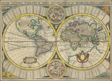
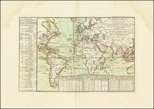
An Early Integration of Cook's Discoveries in Hawaii, New Zealand and Australia.
Rare separately published double hemisphere map of the world, issued by Clouet and Mondhare in Paris.
The discovery of Hawaii (Ile Sandwich ou Why, as named on the map) and explorations in the Northwest Coast of America are quite prominent.
This is the 1787 update now showing the major 18th century explorers like Cook (1773,1775, 1776, 1777, 1778), Bougainville (, Halley (1700), Clarcke (1779). The Russian track of 1741, among the early voyages by Magellan (1520), Pedro Fernández de Quirós (1605 - Who proclaimed Australia the "Southern land of the Holy Spirit" on the Day of Pentecost, 14th May, 1606), Tasman (1642)
A "Mer de L'Ouest" is labeled but not very obvious present.
East to the tip of Tasmania we see "Frederick Henry Bay". A text panel surrounded by children the published explains that the map has many new explorations in the four parts of the world, especially in Canada, Baffin Bay, and by explorers like Tchirikow (1741) and Cook and Bougainville.
Jean-Baptiste Louis Clouet (1730-ca. 1790) was a mapmaker with premises in both Paris and Cadiz. He was eventually named Royal Geographer of the Academie des Sciences de Rouen. Although he made several lavish wall maps, he is best known for Geographie Moderne (1776-93).
![[Coffee, Tea, Vanilla & Spices / Pictorial Map of the World -- McCormick & Company]](https://storage.googleapis.com/raremaps/img/small/100117.jpg)