
This item has been sold, but you can enter your email address to be notified if another example becomes available.


|
||

|

|
|

|
Stock# 61530
Description
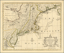
Scarce map of Pennsylvania, New Jersey, Maryland and parts of Delaware and New York, showing the region from the Upper Chesapeake and Delaware Bays to Lake Erie and Lake Ontario, published in Morse's American Geography.
One of the earliest maps of the region to be published in the United States in a geographical book, pre-dating the first American Atlas by Carey (1795).
Condition Description
Minor toning.
Reference
Wheat & Brun 438.
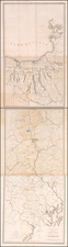
![[ St. Lawerence River / Lake Champlain ] Carte Du Cours Du Fleuve De St. Laurent Depuis son Embouchere jusqu'au dessus de Quebec . . .](https://storage.googleapis.com/raremaps/img/small/101652.jpg)
![(Early Philadelphia Architectural Drawings) Plan of the ceiling of St. Andrews Church [with two additional drawings on another sheet]](https://storage.googleapis.com/raremaps/img/small/90443.jpg)