|
||

|

|
|

|
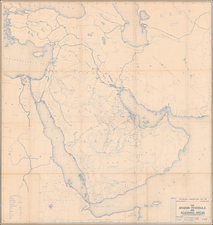
Highly-Detailed Military Map of Yemen from the Yemen Civil War
Minutely-detailed map showing the eastern half of modern-day Yemen. It was intended “For Official Use Only,” as the bottom of the map reads, and was not designed for public consumption.
The text is in Arabic with transcriptions in the Roman alphabet. A note in the lower right explains that the map was, “Drawn on the basis of the military section in 1962.” Which military is not identified, but the Yemen Civil War was an international incident involving Egypt and Saudi Arabia, and drawing interest from Britain, which still had colonial outposts in the area, the US, and the United Nations, among others.
The map includes a scale in both miles and kilometers and it is represented both graphically and in ratio form (1:500,000) in an oval with the title at the top left corner of the first page. The bottom right corner of the second page offers an extensive key explaining the symbology scattered thickly over the territory. It includes coastlines, rivers, Wadi (ravines), wells, springs, reservoirs, cities, settlements, multiple types of boundaries and roads, ports and mountain passes, mountains, contour lines, lowlands, volcanoes, sandbars, coral reefs, sand areas, swamps, salt marshes, date palms, ancient ruins, mosques, tribes, and elevation.
Yemen’s Civil War: 1962-1970
After a 1962 coup led by Egyptian forces, an insurgency ignited in Yemen. Saudi Arabian troops supported the push to restore old order, causing Egypt’s president at the time, Gamal Abdel Nasser, to send in military reinforcements to support Yemen’s new government. Defeated in the Arab-Israeli Six-Day war in 1967, Egypt finally withdrew their troops, leaving the conflict in Yemen to slowly continue until moderate leaders surfaced to fill the power vacuum. Based on the inclusion of English transcriptions, this map was likely created by a Western power to allow for better knowledge of the area during the war.
This map would appeal to those interested in the history of Yemen’s Civil War, as well as the Middle East and Middle Eastern conflict.

![(Arabian Peninsula) [Sexta Asie Tabula, Arabia Felix.]](https://storage.googleapis.com/raremaps/img/small/94180.jpg)
![[ Jordan ] Tourist Map -- The Hashemite Kingdom of Jordan](https://storage.googleapis.com/raremaps/img/small/97635.jpg)