


|
||

|

|
|

|
"The Earliest Geological Map of America" - Roy Porter
This book comprises the memoirs of Jean-Étienne Guettard presented before the National Academy of Sciences 1752 regarding the geology of Canada, as well as maps by Philippe Buache based on this work, printed in 1756. The main text compares the geologies of Canada and Switzerland and is remarkable for showing possibly the earliest example of global stratigraphic correlation. Interestingly, neither Guettard nor Buache visited North America before publishing this work. While the ideas behind the text would become outdated as soon as half a century later, they represent a critical step in the geological scientific process.
The text describes the mineral and resource riches of Canada. It would have been an important text in Europe to show how important the North American colonies could be in helping to further enrich their colonizers. Published two years before the onset of the French and Indian War, it is likely that colonial powers would have seen these mineral riches as a reason for expansion.
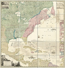
This work includes a rare example of the oldest geological map of North America as accepted by historians. While rudimentary, it has all the hallmarks of a geological map. This map represents an alternative way of mapping geology than that popularized by William Smith and accepted to the present day, with this version being more akin to how drift lithologies are presently mapped. In addition, the work includes the earliest engravings of North American Ordovician fossils. As such, this work is a key text in the progress of science in North America and throughout the world.
The oldest geological map of North America
Historians of science define the key criterion of a geological map as one which extrapolates the position of strata (rock types, or "earths" in this work) without having seen them at surface. This is in contrast to maps of resource distribution, which may show the positions of certain quarries or outcrops, but make no inference as to what lies between them. While earlier maps of North America do the latter, as in Lewis Evan's maps of 1749, 1751, and 1755, they make no claims to extrapolate the positions of rocks not seen at the surface. As such, Guettard and Buache's map is considered the oldest geological map of North America.
The different rock types mapped in this work are: a "bande sabloneuse," a "bande marneuse," and a "bande schiteuse métallique." Respectively, these cover: sands, marls and sandstones from the continental shelf; limestones with no metal other than iron from coastal areas; and finally shales, slates, sandstones, schists, granites, etc. in inland areas poor in fossils but rich in metallic deposits and hot springs. While we now know that such strata are unlikely to represent cogenetic groupings, one could imagine where Guettard got this idea. His only resources for the offshore areas were Caribbean islands rich in sand and marls. Along the North American coast, limestones are very common, and fossils abundant though ore deposits rare. Inland, orogenies and other processes have resulted in highly variable rock types, abundant ore deposits, and hot springs. In addition, the samples which Guettard worked with were limited and generally conformed to the above groupings when classed according to location. As this data seemed to match Guettard's theory of rock formation (discussed in the next paragraph) he extrapolated these bands to large areas in a way we now know to be incorrect.
This map includes representations of the theory of "Neptunism," now attributed to Abraham Werner, which seeks to explain the deposition of different rock types through a shrinking ocean. In this theory, a global ocean with a heterogeneous seafloor precipitated certain rocks at different stages. The differences in the three main periods of rocks deposited correspond to changing conditions of the ocean, which is taking to influence a wide variety of factors, such as the crystallinity of rocks or their fossil contents. Attributing this map to a version of that theory, the "bande schiteuse métallique" would be from the primary (first) period, and represent the oldest rocks deposited during calm seas. The "bande marneuse" would represent a transitional (second) period, in which some of the properties of both the primary and the floetz (third) period are preserved. Floetz refers to the conditions of the modern oceans, responsible for the "bande sabloneuse" and deposited in chaotic modern oceans.
In addition to the three bands of lithologies, the map shows the locations of 39 different types of rocks, ores, and geological processes. These reflect some key resources of the period, such as copper-bearing rocks, as well as more general observations, such as the location of hot springs. One label, "tierre tremblante," may even record the position of earthquakes.
Canada and Switzerland: An unusual comparison
Guettard's memoir centers on comparing the mineralogies found in Canada and Switzerland. He commences by praising the riches of Canada, and then suggests that these riches may not be that different from those found in Switzerland. This latter country is only chosen as it is where he has the most personal geological experience. While at first a comparison between these two areas might appear preposterous without the benefits of modern geology, Guettard presents compelling reasons for why he thinks they are alike. The memoir notes that the samples of rocks and fossils that he had been sent were not dissimilar to those he has collected in Europe. In particular, Guettard uses fossil evidence to try and correlate stratigraphies, a method that was well ahead of his time.
While Guettard's underlaying theory on these rocks may have been very incorrect, his case for similar stratigraphies on either side of the Atlantic was very important in showing uniformitarianism of processes in space. He made the connection that since he was observing the same products, whether they be ore deposits, sedimentary rocks, or fossils in both areas, they must have been deposited by similar processes. This was an important proof of an idea held in various forms since Greek philosophers.
Guettard even hints at trying to correlate specific stratigraphies across the ocean. He suggested that the "bande marneouse" might extend through Greenland to Europe, basing this idea off his theory and fossil evidence. While the reasoning behind this idea was weakly founded, it is notable that this band would nearly follow the global outcrop of Caledonides. As such, this is likely the first example of intercontinental stratigraphic correlation.
Guettard structures his text by first presenting the mineralogies of the specific rocks he has been sent from North America, followed by his observations from Switzerland. He then compares the two, showing that the rock types and fossils in the two regions are similar. As such, this work is not that different than modern research which covers the same topics. This is not the first work by Guettard which seeks to compare the geologies of disparate regions; in a previous text he compared the granites of Egypt and France and shows that they are similar .
Early fossil lithographs from North America
This work includes several lithographs, which have been attributed by Wells to be the earliest fossil lithographs showing North American Ordovician fossils. Included are lithographs of two fish skeletons, a variety of bivalves, and two other structures which evade initial explanation. While these could be biogenic, further research would be needed to identify what exactly these final two sketches seek to represent.
From Mineralogy to Geology: The Foundations of a Science, 1650-1830 (Section 5, Lauden)
![[Olivier van Noort Portrait / World Map]](https://storage.googleapis.com/raremaps/img/small/79567.jpg)
![[California Wine Advertising Graphic] Italian Swiss Colony Producers of Choicest California Wines Asti Colony Tipo](https://storage.googleapis.com/raremaps/img/small/83467.jpg)