This item has been sold, but you can enter your email address to be notified if another example becomes available.


|
||

|

|
|

|
Stock# 61359
Description
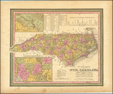
Nice example of Desilver's map of North Carolina, with insets of the Gold Region (centered on Cabarus and Montgomery Co), the Neuse River and New Berne.
Shows towns, roads, railroads, rivers, mountains, lakes, creeks, canals, etc. Canals are noted in red. Rail lines and proposed rail lines are also shown.
The map was first issued by HS Tanner and appears in various formats until the late 1850s. The history of North Carolina and its counties from 1830 to 1860 can be tracked through the various editions of this map, as the plate is re-engraved by Tanner, Mitchell, Cowperthwait, Desilver, etc. Includes a table of distances and profile of the Dismal Swamp Canal.

![[ Cherokee Nation ] A Map of the Tennassee Government formerly Part of North Carolina from the latest Surveys. 1795.](https://storage.googleapis.com/raremaps/img/small/100899.jpg)