|
||

|

|
|

|
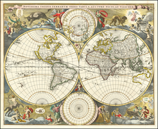
Eye-Catching Dutch Double Hemisphere World Map
Striking, old-color example of Allard's elaborately-decorated and rare double hemisphere map of the world.
The finely-engraved larger hemispheres show the western and eastern sides of the globe in sharp, yet minimalist, detail. In the west, California is an island on the Briggs model. A single, open Great Lake is shown, consistent with Jan Jansson's map of North America from 1636. South America is mis-projected and shown far wider than its actual shape. Tierra del Fuego is insular and is similar to the island as drawn on the maps of Blaeu.
In the Pacific, a small unfinished Anian is separated from the Pacific Northwest by a suggestive strait. The North Pacific is largely empty, but two belts of islands, the result of Spanish and Dutch expeditions in the sixteenth and seventeenth centuries, are to the north and south of the equator. The west coast of New Zealand is also present, a reference to the voyages of Tasman a half-century earlier.
In the east, Australia’s coastline is partially outlined, with some gaps. This outline is the result of Dutch expeditions that contacted the continent en route to the East Indies. New Guinea and Australia are nearly connected, a common conception at the time. The northwest corner of Asia is blunted, with no chance of connecting or extending toward North America. The islands of Maritime Southeast Asia are particularly detailed, another reference to the intense Dutch trading presence there.
The larger double hemispheres are joined by complimentary smaller polar circles. The north polar circle shows Greenland connected to North America via Baffin Bay. The Strait of Anian is visible, but the geography of the pole itself is left empty. All that is seen on the south polar circle is a snippet of Tierra del Fuego—the hypothesis of a vast southern continent is just that here, an idea with no visual extent (or limit). The geographic details throughout the map draw on the work of Visscher from ca. 1660, according to Shirley.
Perhaps the most compelling aspect of the map, besides its relative rarity on the market, are the decorative elements that fill the area around the hemispheres. The map’s title is engraved on a banner unfurled along the top of the plate. Sandwiched between the hemispheres are winged cherubs, one holding a cross and the other a doll.
Drawing on decorations used by De Wit in his second wall map of the world (ca. 1670), each corner houses its own vignette that combines a season with its zodiac symbols.
- Spring is in the upper left, surrounded with nature’s bounty and a bull, referencing the zodiac sign of Taurus. The ram of Aries is in the background, while the female figure carries the twins of Gemini at her hip.
- Summer, in the upper right, brings in the harvest. A lion (Leo) helps, while a cherub carries the crab (or lobster) of Cancer. The virgin, Virgo, sits in the background, watching.
- Autumn, in the lower left, shows a bacchanal with men, carried by satyrs, drinking to excess; one is being sick on the ground. The attendant cherubs carry scales (Libra) and a scorpion (Scorpio). A centaur hunts to the right, a reference to Sagittarius.
- Old Man Winter braves a harsh landscape; one of his minions holds two fish, a reference to Pisces. Another cherub pours water, serving as the water bearer of Aquarius. Others drag a goat between them (Capricorn).
California as an island
One of the most striking geographic elements of this map is the portrayal of California as an island. From its first portrayal on a printed map by Diego Gutiérrez, in 1562, California was shown as part of North America by mapmakers, including Gerardus Mercator and Ortelius. In the 1620s, however, it began to appear as an island in several sources.
This was most likely the result of a reading of the travel account of Sebastian Vizcaino, who had been sent north up the shore of California in 1602. A Carmelite friar who accompanied him later described the land as an island, a description first published in Juan Torquemada’s Monarquia Indiana (1613) with the island details curtailed somewhat. The friar, Fray Antonio de la Ascension, also wrote a Relacion breve of his geographic ideas around 1620. The ideas spread about New Spain and, eventually, most likely via Dutch mariners and perhaps thanks to stolen charts, to the rest of Europe.
By the 1620s, many mapmakers chose to depict the peninsula as an island. These included Henricus Hondius, who published the first atlas map to focus solely on North America with the island prominently featured in 1636. Hondius borrowed his outline of California from another widely distributed map, that of Henry Briggs and printed in Samuel Purchas’ Hakluytus Posthumus or Purchas his Pilgrimes (1625). The Briggs model is seen on this map. Other prominent practitioners like John Speed and Nicolas Sanson also adopted the new island and the practice became commonplace.
Father Eusebio Kino initially followed along with this theory, but after extensive travels in what is now California, Arizona, and northern Mexico, he concluded that the island was actually a peninsula. Even after Kino published a map based on his travels refuting the claim (Paris, 1705), California as an island remained a fixture until the mid-eighteenth century.
Strait of Anian
Another element seen twice on this map, in the western hemisphere and the north polar circle, is the Strait of Anian. This strait, believed to separate northwestern America from northeastern Asia, was related to the centuries-long quest to find a Northwest Passage connecting the Atlantic Ocean to the Pacific. Appearing on maps beginning in the mid- to late-fourteenth century, the rumor of this strait and a Northwest Passage in general inspired many voyages of discovery, including those of John Cabot, Sir Francis Drake, Gaspar Corte-Real, Jacques Cartier, and Sir Humphrey Gilbert.
The term Anian itself comes from Marco Polo’s thirteenth-century accounts of his travels. Polo used the term to refer to the Gulf of Tonkin, but cartographers at the time of Jansson thought it could refer to this supposed strait between Asia and North America. The Strait of Anian, so named, first appeared in a 1562 map by Giacomo Gastaldi, and was later adopted by Bolognini Zaltieri and Gerardus Mercator.
A few decades later, English financier Michael Lok advanced the story of Juan de Fuca (the Castilianized name of Greek navigator Ioánnis Fokás), who supposedly sailed the Strait of Anian. Little archival evidence survives of Fuca’s career, but according to Lok, Fuca reported that he had been sent north from New Spain twice in 1592 in search of the Strait of Anian.
Fuca supposedly traveled up a vast straight at the northernmost point of the west coast of America, around which he sailed for more than twenty days. The Spanish Crown failed to reward Fuca’s discovery of an opening in the coast at roughly 47° N latitude and Fuca left the Spanish service embittered. His story lived on in Lok’s letters and eventually was published in Samuel Purchas’ travel collection of 1625. Fuca’s account helped to keep this chimerical strait on many maps of the time. It was not until 1772 that Samuel Hearne conclusively disproved the strait’s existence.
States and rarity
According to Shirley, Allard produced this world map before 1683, the year he received a privilege to print. There are two states. The first has no privilege included in the lower right corner, while the second state, of which this is an example, does have the privilege statement.
Both states are scarce. OCLC only lists the British Library, Stanford, the University of Bern, UC Berkeley, and the University of Basel as having examples, although the Australian National Library also has one in their collections (state-specific information was not included in their cataloging).
Carel (Carol) Allard (Allardt) (1648–1709) was an engraver and publisher based in Amsterdam. Part of a prominent family of Dutch mapmakers, publishers, and print sellers, his father was engraver and publisher Hugo Allard (1627–1684), who left his business to Carel upon his death. Carel published anything in demand, including maps, topography, ethnography, newsprints, and restrikes of old plates of artistic prints, many of which likely came from his father’s stock. In 1706, Carel gave his copperplates to his son Abraham Allard, before going bankrupt.
![P. Mc.D. Collins' Proposed Overland Telegraph Via Behring's Strait and Asiatic Russia to Europe, Under Russian & British Grants. . . 1864 [accompanied by separate text:] Communication of Hon. William H. Seward, Secretary of State, upon the subject of an Intercontinental Telegraph connecting the Eastern and Western Hemispheres by way of Behring's Strait, In Reply to Hon Z. Chandler, Chairman of The Committee on Commerce of the U.S. Senate, To Which Was Referred The Memorial of Perry McDonough Collins.](https://storage.googleapis.com/raremaps/img/small/87461.jpg)